As Azerbaijan Consolidates Control, Armenians Flee Nagorno-Karabakh
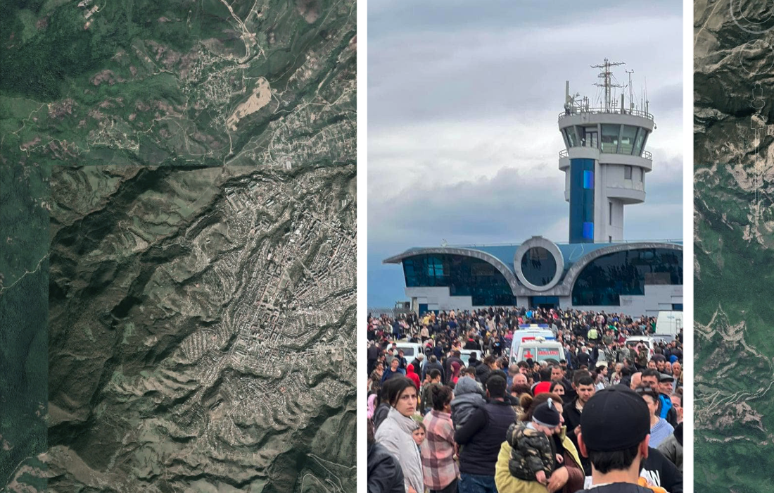
Newly obtained satellite images show the mass exodus of people from the Nagorno-Karabakh region, where fears of the ethnic cleansing of Armenians have escalated since Azerbaijani forces launched an offensive there last week.
Other open source data collected by Bellingcat confirms ongoing Azerbaijani military presence in communities ethnic Armenians have fled from.
Azerbaijan’s attack last week exacerbated an ongoing humanitarian crisis in Nagorno-Karabakh set in motion by a nine-month blockade of the self-governing territory. Fears of ethnic cleansing have prompted thousands of civilians to seek safety in neighbouring Armenia. Over 70,000 ethnic Armenians have fled since Baku launched the offensive last week according to Nazeli Baghdasaryan, the press secretary of Armenia’s Prime Minister Nikol Pashinyan.
Armenian civilians entering Armenian territory have told journalists of cases of Azerbaijani soldiers committing human rights violations. For example, Armenian investigative website Hetq published the testimonies of a family from the village of Vaghuhas, who say that Azerbaijani soldiers fired weapons and demanded that all Armenians leave. Bellingcat has not been able to independently verify these claims. Azerbaijan’s Ministry of Health said on Wednesday that 192 members of its armed forces have been killed and 511 injured.
Human rights groups and intergovernmental organisations, including the UN, continue to push for access to Nagorno-Karabakh.
Since the latest escalation of this long-running conflict, Bellingcat has monitored open source information in an attempt to understand the scale of this crisis and is consistently archiving footage from the area.
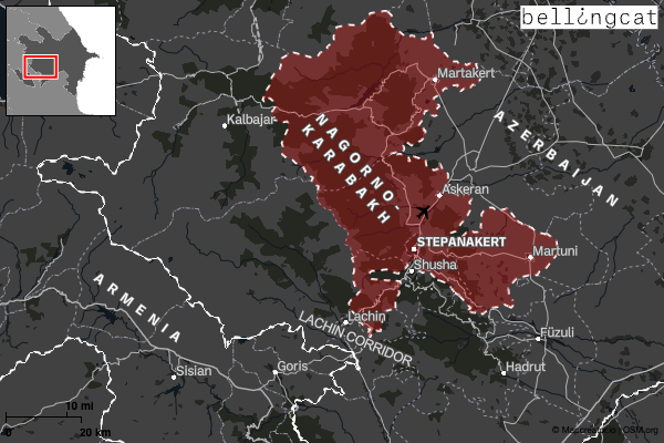
Satellite Imagery from Martakert
Bellingcat obtained Planet satellite imagery from Martakert on September 24. It showed a large queue of vehicles leaving the city towards the west. The vehicles all halted (40.221, 46.791), possibly due to a roadblock. No queues could be observed at any other road out of the city which is visible in the satellite imagery.
Interestingly, these vehicles are heading along a northern road to the Sarsang Reservoir, which appears to have come under Azerbaijani control by September 22. A video posted on TikTok one day earlier shows Azeri-speaking people in military uniform near the reservoir (40.213, 46.800).
We don’t know exactly why these vehicles took the more northerly road, which goes via the Sarsang Reservoir. The southern road would normally be another route into Stepanakert and the Lachin corridor.
‘Martakert is Ours’
Open source evidence buttresses claims that Martakert is now under the control of Azerbaijani forces.
Bellingcat found multiple mentions of civilians fleeing the city of Martakert – known as Ağdərə in Azerbaijani- and surrounding villages in the east of Nagorno-Karabakh. Several gave interviews in Karabakh’s de-facto capital of Stepanakert, where Russian peacekeepers remain. Martakert came under the control of the self-declared Armenian government of Karabakh in 1992. Sections of the neighbouring Agdam Region were transferred to Azerbaijani control after the 2020 war, leaving Martakert one of the last cities in Karabakh near the line of contact (the front line separating Karabakh Armenian and Azerbaijani troops).
Mass movement from Martakert is one case study that demonstrates the scale of displacement currently occurring within Karabakh.
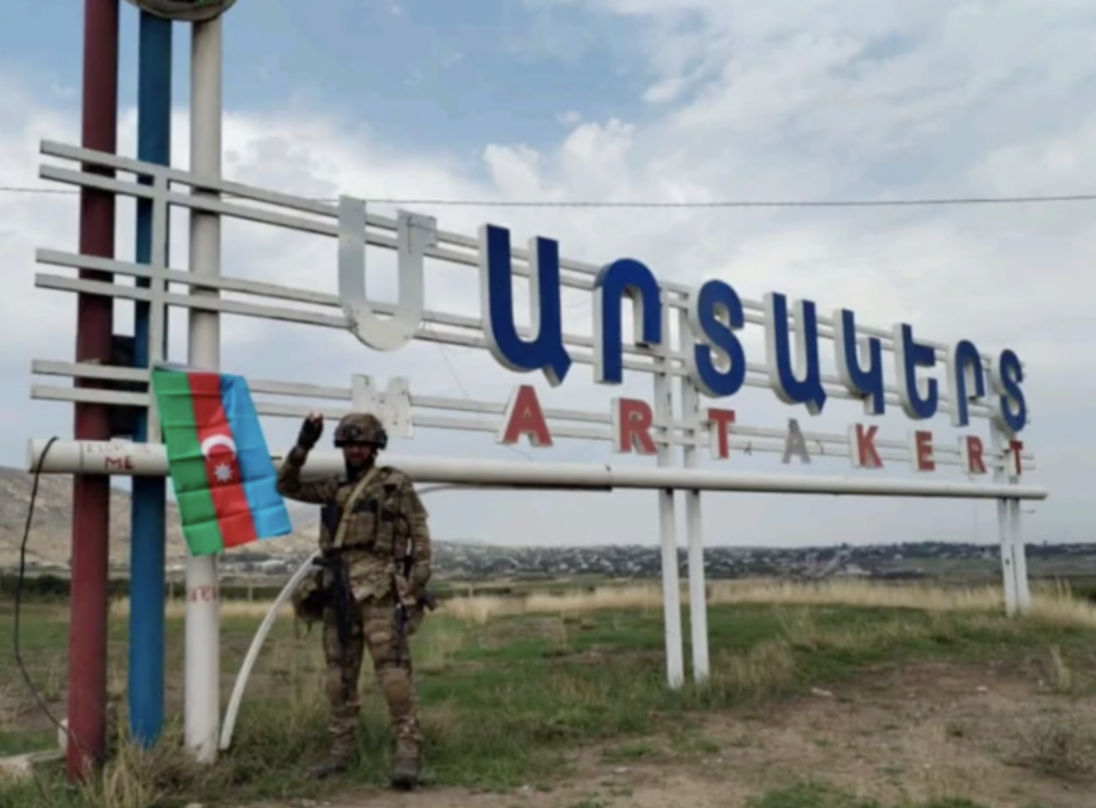
The below image, posted to TikTok on Sunday, September 24, shows an Azerbaijani soldier standing at the entrance to the city. The sign gives Martakert’s name in Armenian (40.191459, 46.818861).
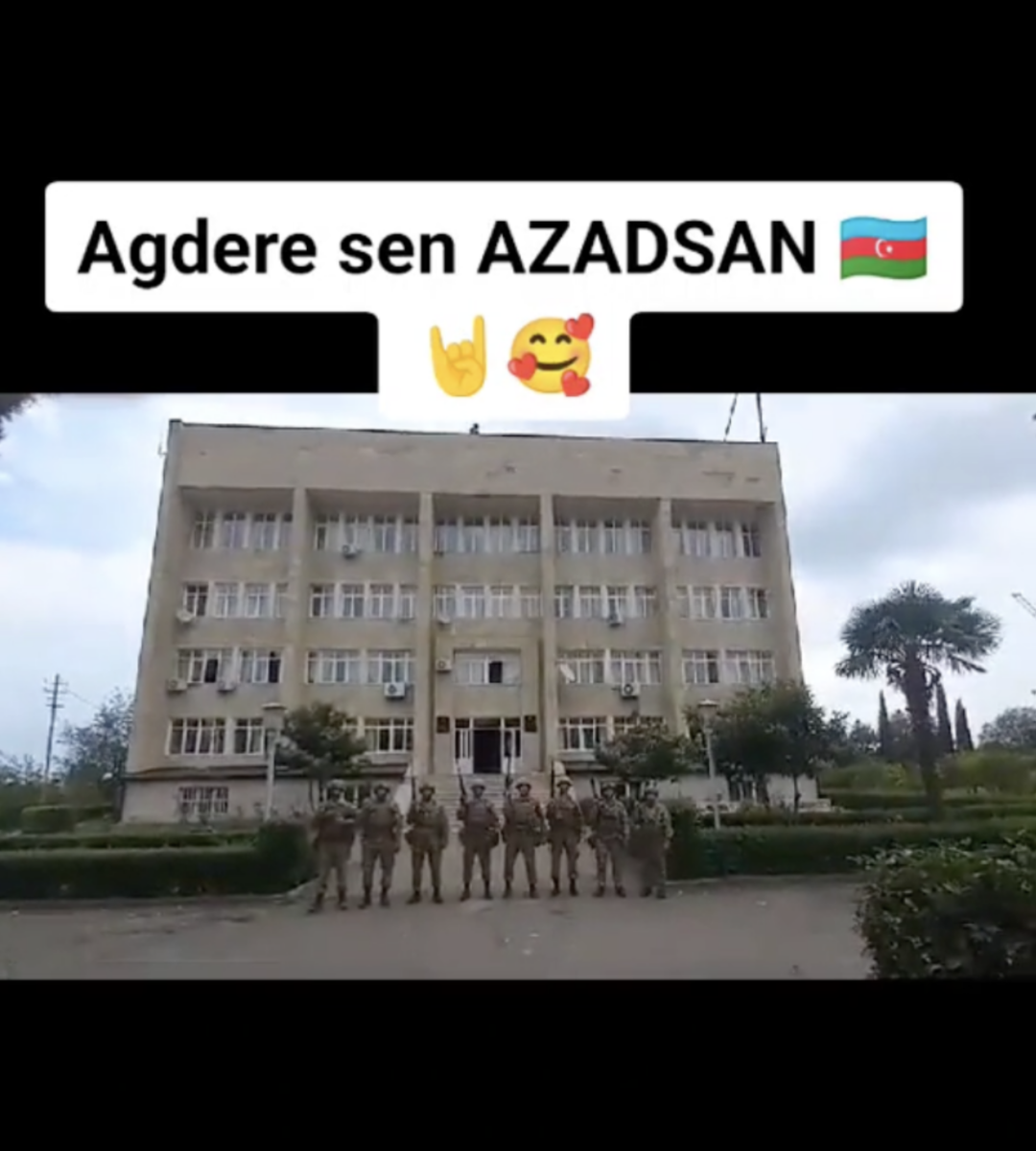
A group of Azerbaijani soldiers also posed for a photo in front of Martakert’s regional administration building (40.215012, 46.826210) posted to TikTok on September 26, suggesting control of the city centre. The text reads ‘Agdere you are free!’ in Azerbaijani.
Flags of the de-facto Republic of Artsakh could be seen on the ground in front of the same building in a video filmed by an Azerbaijani-speaking individual and posted to X on September 26.
Videos have also surfaced that show Azerbaijani soldiers inside abandoned homes. This video states that it is of an ‘Armenian house in Ağdərə’ although its precise location cannot be determined due to landscape features not being visible.
Four days earlier, a TikTok user posted a video of civilians waiting near Martakert’s administration building with the words ‘Artsakh, Martakert’ (40.215243, 46.826023).
On September 24, one Armenian resident filmed cars leaving the city on Azamartikneri Street (40.2150665644, 46.8161031938).
“People are stunned, packed, in a motorcade, all of them crying…one’s heart breaks, my heart breaks… it’s simply shattered. What is this? running around aimlessly, going insane. Goodbye my homeland, my Martakert. My heart doesn’t function anymore…” says the woman.
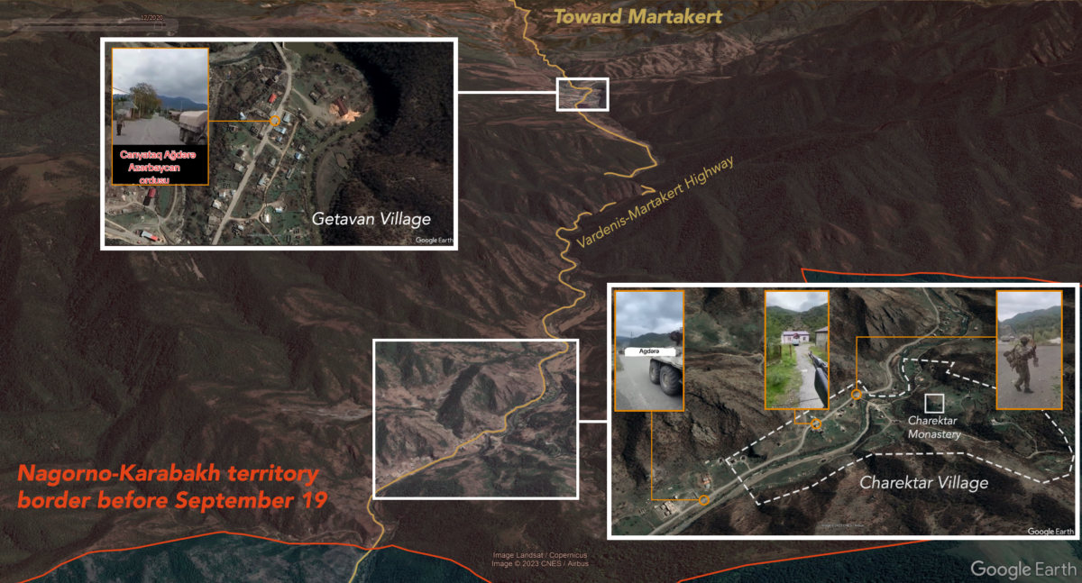
The term ‘Ağdərə’ has also been used by Azerbaijanis online to refer to other towns in the Martakert region of Karabakh, such as in this video, originally posted on Telegram, of an Azerbaijani military ambulance filmed in the town of Getavan, known in Azerbaijani as Qozlukörpü (40.130363, 46.456043) and this video, originally posted on TikTok, which the user captioned as having taken place in Çanyataq, but was also filmed near Qozlukörpü (40.129221, 46.462222).
A video from the town of Charektar, known in Azerbaijani as Çərəkdar, shows Azerbaijani soldiers and an armoured vehicle firing in the direction of a group of houses (40.137779, 46.344075), with the 13th-century Charektar Monastery visible on a hilltop above. The landscape matched that seen in the below Mapillary street view; a silhouette of the monastery on the hilltop can also be seen in this Flickr image from 2014.
Another video of an Azerbaijani armoured personnel carrier and troops captioned ‘Agdere’ was uploaded to TikTok on September 21.
It was also geolocated to the river valley north of Charektar (40.144572, 46.339772), also with the help of a Mapillary street view.
A further video from Charektar (40.141879, 46.343237), geolocated by Jake Godin of Scripps News, shows the cameraman firing a gun into what appears to be a civilian building.
This is a selection of open source information from one area of Nagorno-Karabakh and may not necessarily be representative of all other districts. Nevertheless, this provides some hints as to the situation unfolding in the area.
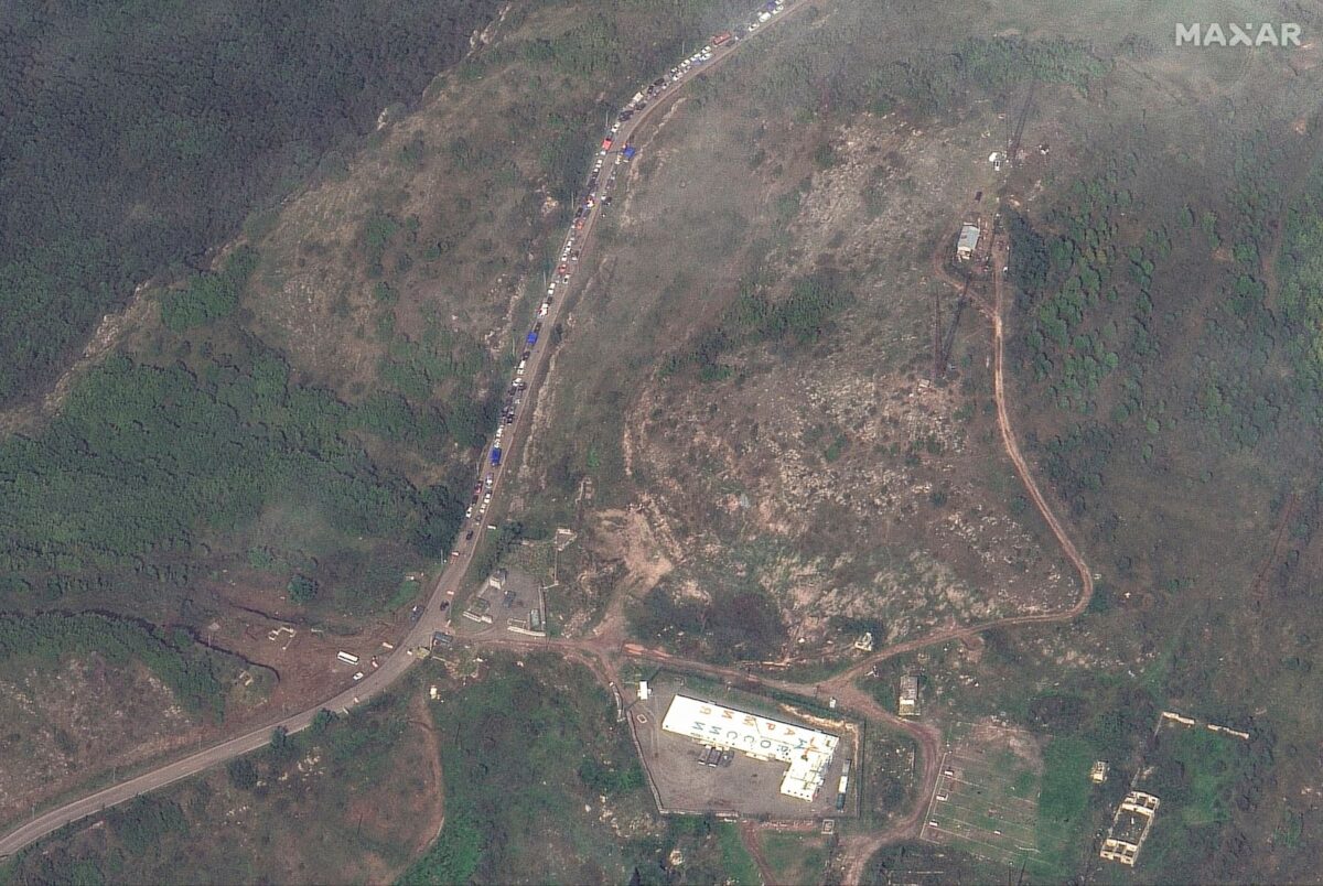
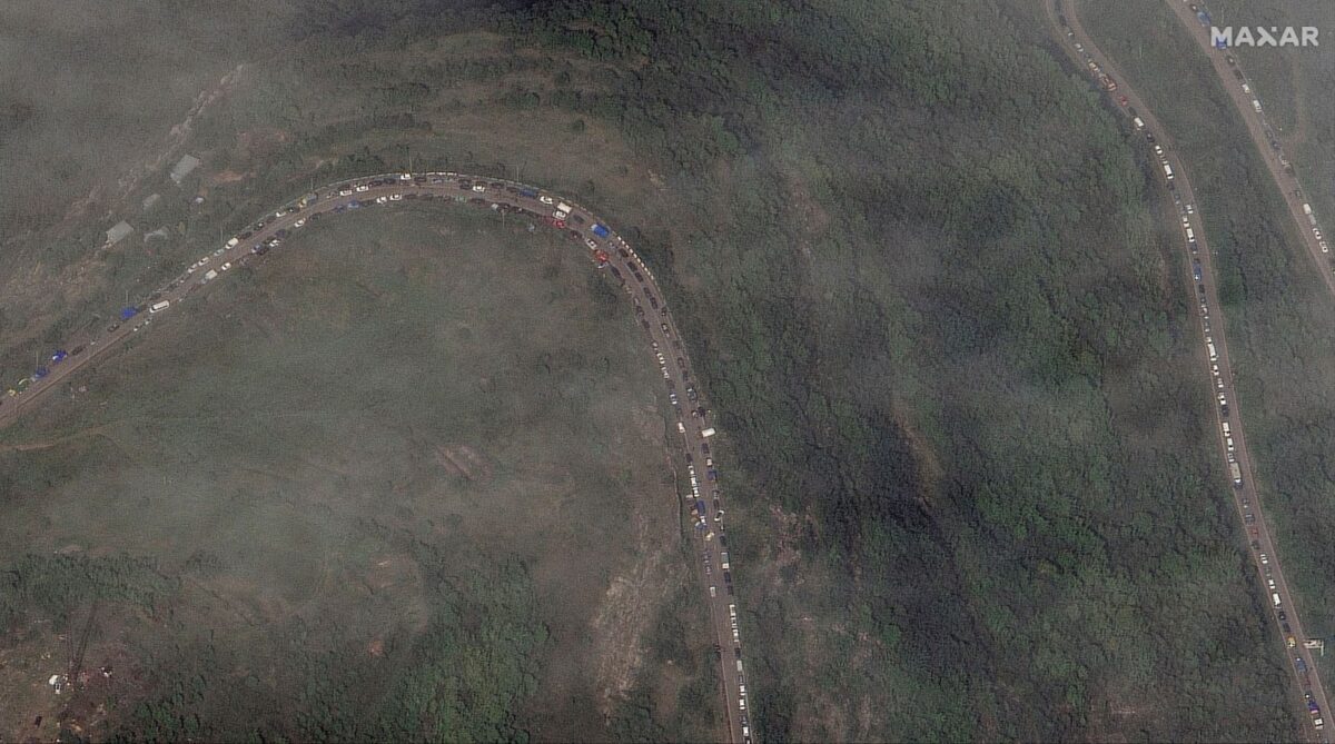
The Road to Armenia
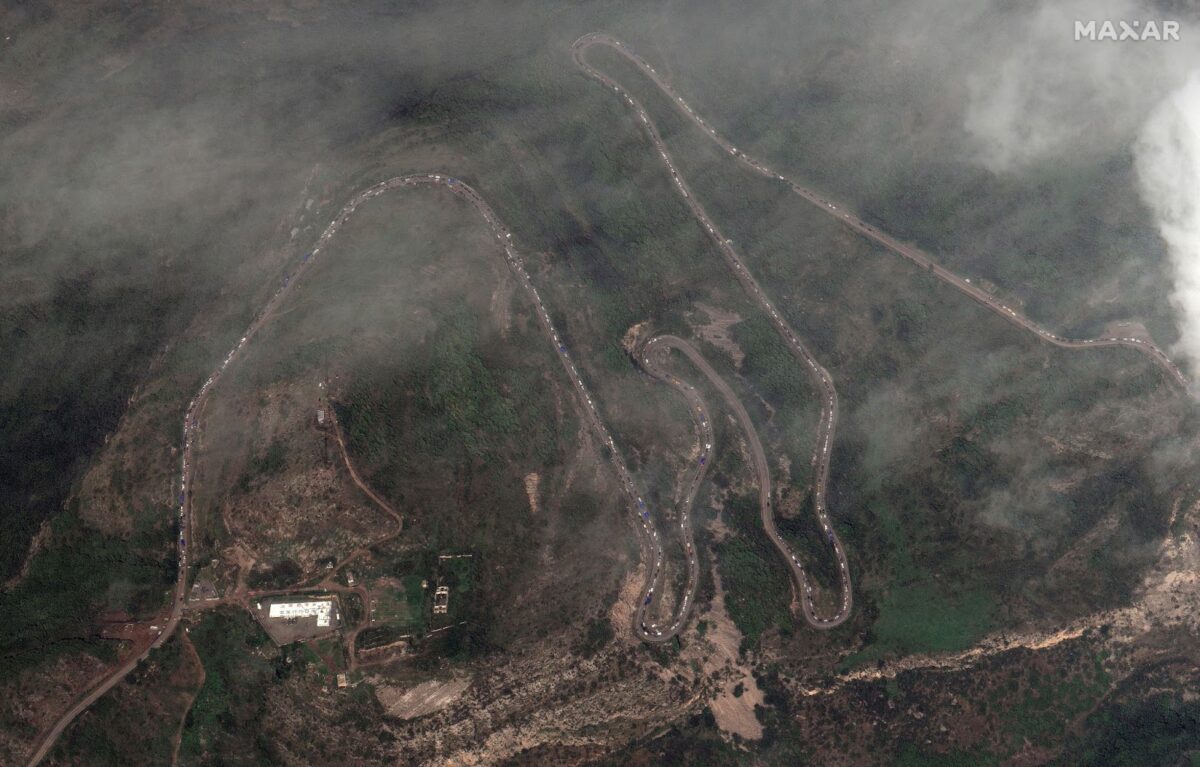
Bellingcat also obtained three Maxar satellite images from September 26 which show congestion along the Lachin Corridor towards Armenia.
On September 28 CivilNet reported that the leaders of the Republic of Artsakh had signed a decree on the dissolution of all de-facto state institutions by the start of 2024.
Jake Godin, Maxim Edwards and Logan Williams contributed research alongside members of Bellingcat’s Global Authentication Project (GAP).
Bellingcat is a non-profit and the ability to carry out our work is dependent on the kind support of individual donors. If you would like to support our work, you can do so here. You can also subscribe to our Patreon channel here. Subscribe to our Newsletter and follow us on X here and Mastodon here.
An earlier version of this article gave an incorrect Azerbaijani name for the village of Charektar. This has been corrected.