An Execution Near Sev Lake
Translations:
In recent weeks, two videos detailing the apparent execution of Armenian soldiers by Azerbaijani troops have been posted and shared widely on social media channels.
The footage is graphic and readers are warned that they may find some of the details in this article disturbing.
Bellingcat carried out an analysis of one of the videos, geolocating it (alongside others in the open source community) and identifying several pieces of evidence that would support chronolocation.
The latest escalation
Armenia has claimed that intensive shelling by Azerbaijani forces beginning on September 13 culminated in a “large-scale provocation” in which several border areas were attacked.
While the Azerbaijani government confirmed the attacks, they said they were in response to Armenian provocations. The International Crisis Group (ICG) stated that 207 Armenian and 80 Azerbaijani soldiers were killed.
The violent incidents were just the latest between the neighbouring nations.
In a six-week war in 2020, Azerbaijan seized much of the Armenian-governed Nagorno-Karabakh region, as well as adjacent regions under its control, which had declared independence after the collapse of the Soviet Union. The 2020 war ended in an unstable ceasefire agreement which saw Azerbaijani forces stationed along Armenia’s internationally recognised borders.
This is the context in which recent fighting occurred.
On October 2, Armenia’s foreign ministry said in a statement that it would file a case with the international criminal court (ICC) in relation to footage showing the extrajudicial execution of prisoners of war. Its Azerbaijani counterpart dismissed this as “hypocritical” in a statement of its own and highlighted several historical incidents dating back to the first Karabakh war in 1992 where it said Armenian forces were responsible for “unprecedented massacres”.
Azerbaijan’s statement added that “comprehensive investigations” had been launched by the Military Prosecutors Office of Azerbaijan to determine whether the videos were genuine.
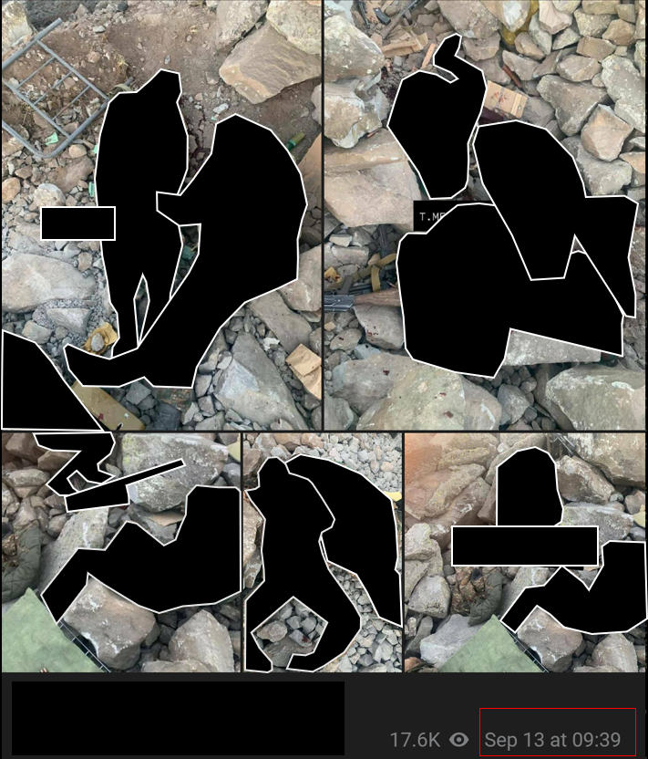
Bellingcat’s analysis of the videos found no clear signs of editing or tampering. Bellingcat has obscured graphic content in stills from the video and associated images from the same location.
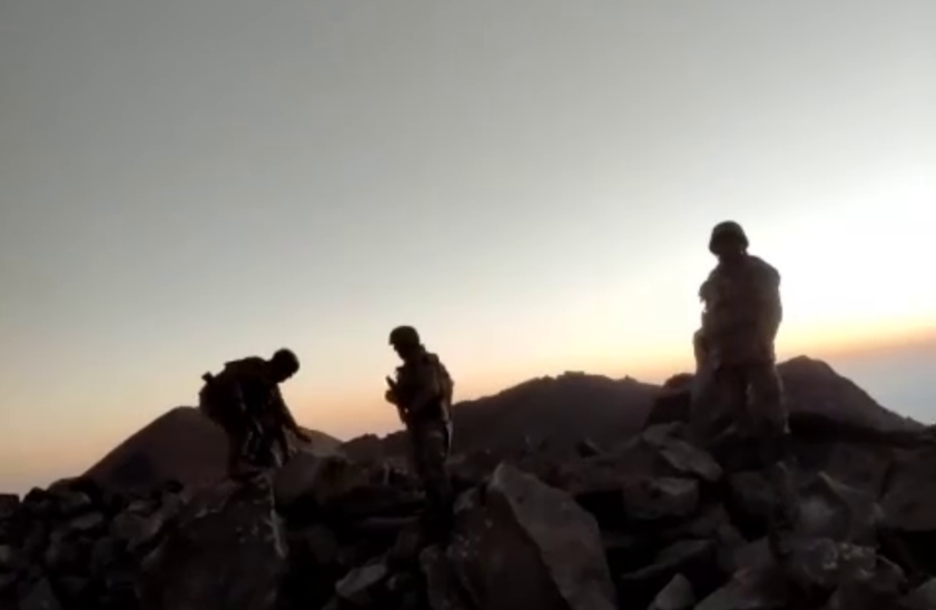
Image still from the video showing three armed men standing on a mountain ridge near Sev Lake.
Geolocating the footage
One of the videos, which depicted the mutilated body of an Armenian servicewoman, first appeared on September 15. It has, at time of publication, not been possible to geolocate this footage.
The second video was first posted on October 1 and depicts a similarly graphic event but a different location. It shows a group of men in military uniforms at a mountain-top position which they have just seized. Another group of men, who appear to have been captured and are wearing different military uniforms, are lined up without their weapons.
Seventeen seconds into the video, at least three men open fire at those who have been lined up and disarmed. Voices shouting “don’t shoot” and “stop firing” in Azerbaijani can be heard, the former just before shots are fired and the latter after the men have been shot. It is not clear who makes these shouts due to the quality of the footage.
The video has been shared widely on pro-Azerbaijani channels, claiming that it showed the execution of Armenian soldiers by Azerbaijani troops.
Both the Azerbaijani language spoken in the video and camouflage patterns on the shooters’ uniforms (as will be explored in detail later) could suggest that they are members of the Azerbaijani armed forces, though the Azerbaijani Ministry of Foreign Affairs told Bellingcat that the authorities are investigating the authenticity of the video and cannot comment on an ongoing investigation.
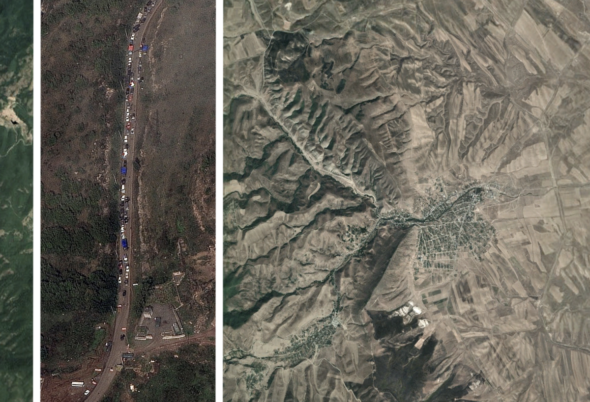
Several posts circulated on Twitter and Telegram shortly after discussing the area around Lake Sev, located at Mount Mets Ishkhanasar, as a potential location for where this video was filmed. However, the coordinates did not appear to match with the footage.
On October 3, the Libération journalists Alexandre Horn and Fabian Leboucq claimed to have geolocated the footage to a mountain ridge in Armenian territory on the border with Azerbaijan, south of the lake.
We (with @LeboucqF) might have found the location where at least 7 armenians POWs were killed by AZ forces sept 13th :
On the mountain ridge around 39.58876519007247, 46.186590873817174 https://t.co/OOqO2mqKg2 pic.twitter.com/27v163jQCN— Alexandre Horn (@Alexandre_HRN) October 3, 2022
Bellingcat had at the time been looking in the same area and has been able to independently confirm Horn and Leboucq’s geolocation.
Looking at the video itself there were interesting features contained within it, but not enough to confirm exactly where the incident took place
A message posted to a Telegram channel focusing on the Azerbaijani military on September 13 provided further clues. It also showed what appeared to be dead Armenian soldiers. Items and elements seen in these images were identical to those seen on the execution video that would be published just over two weeks later.
These included a metal grille, ammo boxes, rocks and distinctive terrain markings. The dead soldiers in these images were also wearing the same uniform as those seen in the execution video and the number visible (nine) was the same in the images and videos.
Pictures found on Telegram and posted on September 13, show what appears to be dead Armenian soldiers over a rocky terrain similar to the one seen on the video. Objects, terrain marks and at least nine dead Armenian soldiers, indicated that both scenes were likely one and the same. Source: Telegram
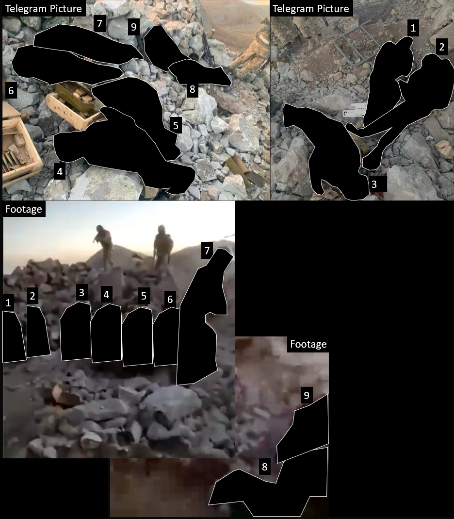
Pictures found on Telegram and posted on September 13, show what appears to be dead Armenian soldiers wearing the same clothing items and positioned in the same respective spots as seen in the video.
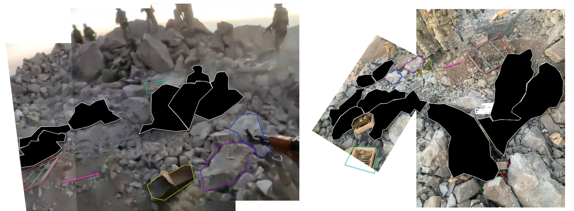
Left: Stitched footage frames. Right: Stitched Telegram images. Identical objects were identified in the same position in both groups of images For example, a metallic piece (red) and ammo box (yellow)
Confident that the footage and images depicted the same incident, we began to look for further clues.
By analysing one of the still images from Telegram, we noticed patterns in the terrain that seemed to be aligned with the position from where the photo was taken. We were able to identify an area around Lake Sev that contained this geographical feature using Google Earth.
Certain patterns in the video could be matched with those seen in the still images found on Telegram
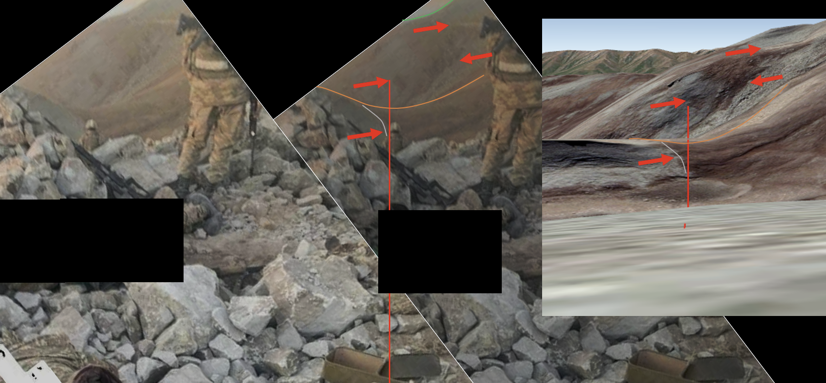
Some of these features were aligned with the position of the camera, allowing us to draw a line across the landscape which assisted in establishing the location.
Tracking a straight line between the location of that pattern in the terrain towards the direction of the camera, takes us to this area on top of a rocky hill here, which can be seen in the animated GIF below:
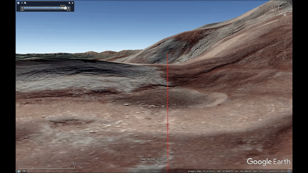
GIF showing how patterns in the terrain helped us to track the location of the camera which took the still images found on Telegram. The tracking process led us to this area on top of a rocky hill. Images: Google Earth Pro: CNES/Airbus-Landsat/Copernicus.
Overlaying this projection with Satellite imagery recently tasked by Bellingcat via Planet Labs, we can see this location was disturbed by human activity.
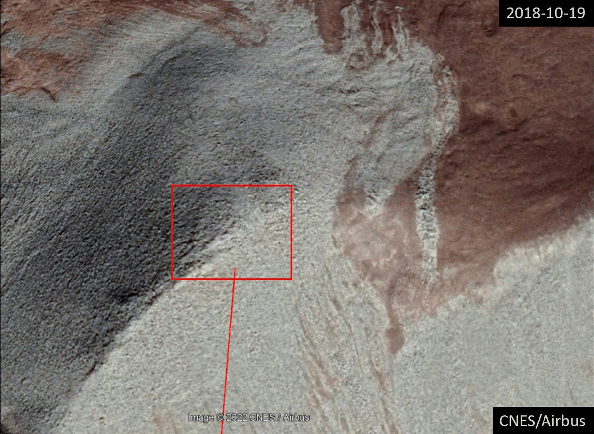
Tracking terrain marks seen on the Telegram pictures led us to this area on top of a rocky hill. Overlapping satellite images show that the ground area around these coordinates seem to have been disturbed recently by human activity most likely in relation to the creation of the military outpost. These images will be explored in more detail later. Image credits: Google Earth Pro: CNES/Airbus-Landsat/Copernicus captured on October 19, 2018. Planet Labs Inc captured on Oct 5, 2022.
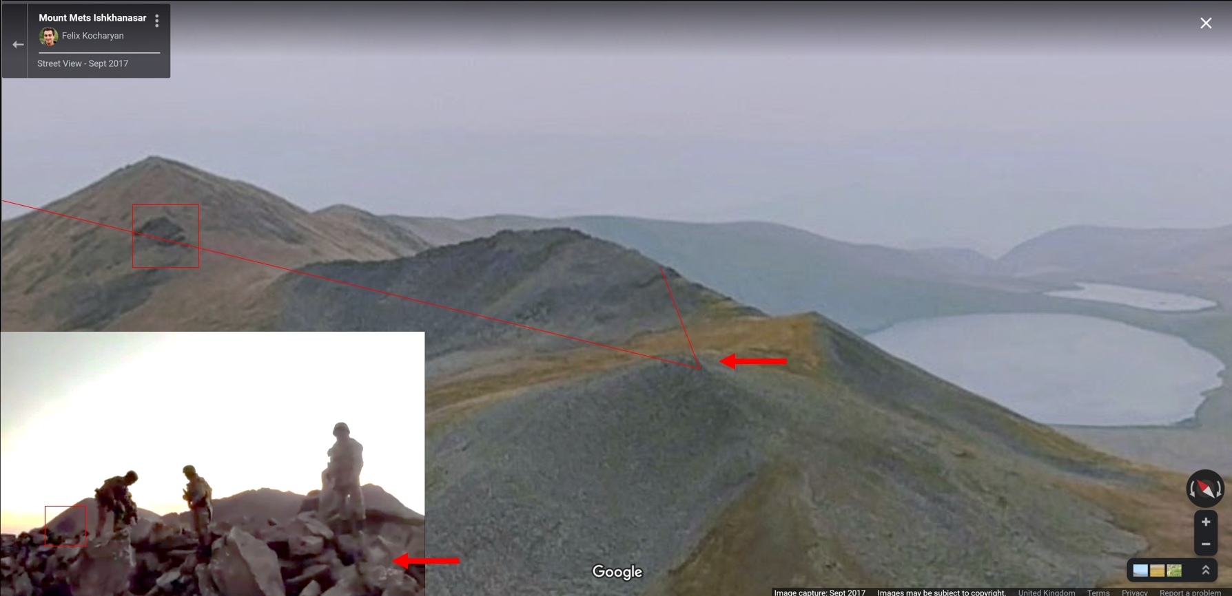
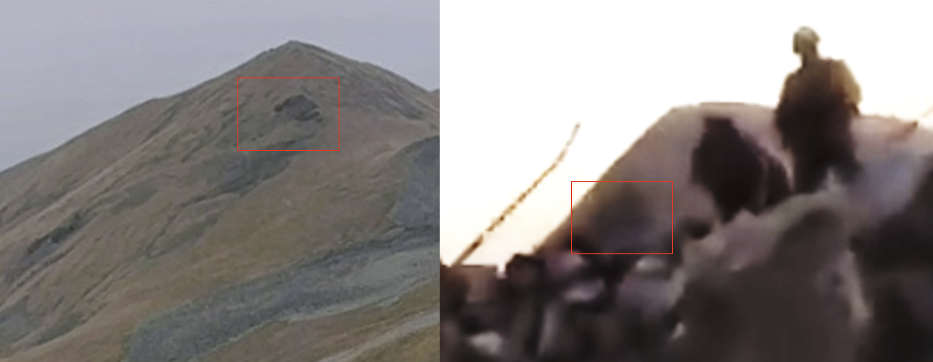
Other photos found online which depict this exact location also show that it contains the same rocky features seen in the graphic images and videos posted to Azerbaijani Telegram channels.
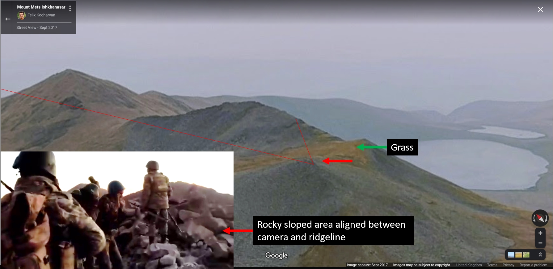
Screenshot of a 360 degree image showing the location of the incident compared to a frame from the footage. The terrain elements caught within the angle of sight of the camera, to the right of the soldiers, match the sloped rocky hill identified in our analysis. Credit: Google Images.
The shape of mountains in the background, as well as the perspective captured by the camera, can also be matched to data found on Peakvisor, a free online tool that allows users to identify mountains in photographs. This technique was also used by Alexandre Horn and Fabian Leboucq from Libération.
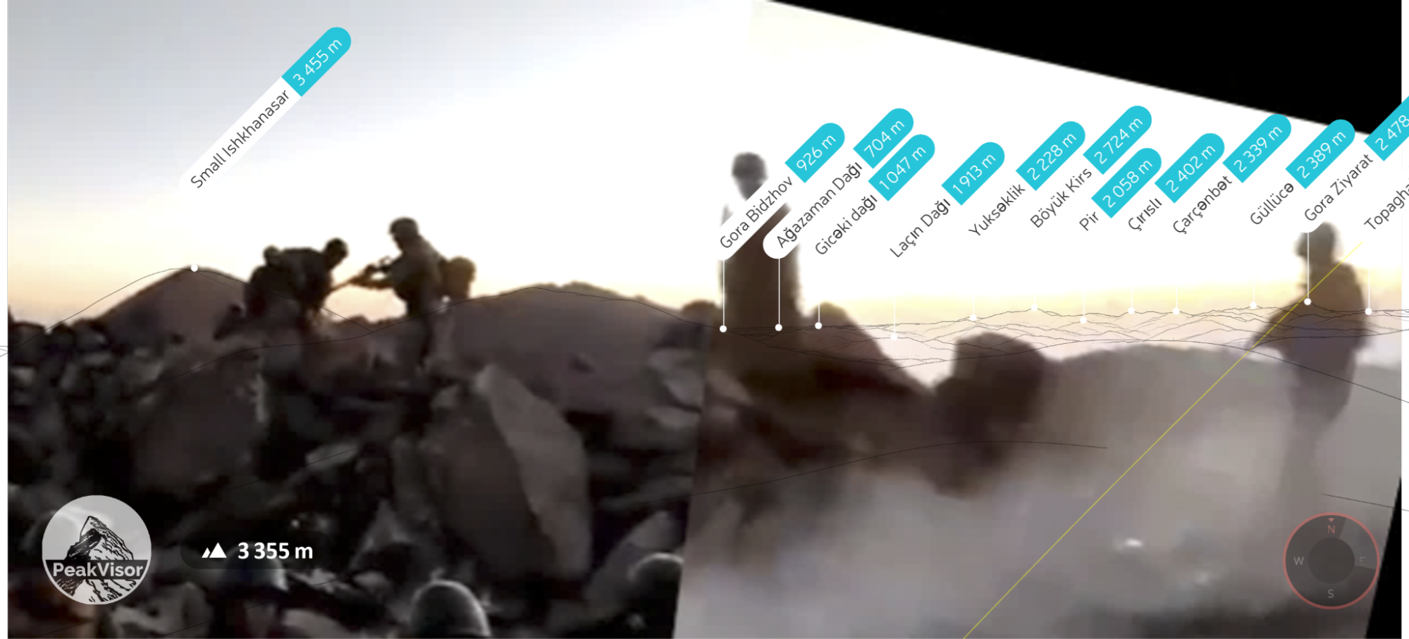
PeakVisor terrain view matched and overlapped to stitched frames taken from the footage.
It must be noted that other reports have suggested this incident took place at another location.
In response to questions regarding this article, the Armenian Ministry of Foreign Affairs (MFA) stated that the incident had taken place at the coordinates 39°36’07.3″N 46°11’45.7″E. However, this is an area just over a kilometre away from the site located by Bellingcat and no match could be found for the terrain there.
On October 3, Siranush Sahakyan, an Armenian lawyer representing the interests of prisoners of war, told Armenian investigative journalism website Hetq that the videos had been taken at a military position known as Hovaz-1 (Հովազ-1), near the Ishkhanasar heights. Sahakyan noted that the Armenian POWs had been identified because the outpost was known. This position, although not an exact match, was very close (600 metres away) to that later identified and verified by the Liberation journalists and Bellingcat.
Sahakyan also alleged that Azerbaijani commando forces trained by Turkey were responsible for the execution of the POWs. Bellingcat was not able to independently confirm this detail.
The Azerbaijani MFA said that it was conducting an investigation into the matter and if any of its soldiers had been involved they would be held to account.
Chronolocating the footage
Other data points contained in the videos can help hone in on the time that the incidents took place.
Given the military operation started just after midnight on September 13, some observers have mentioned the possibility the videos were filmed a few hours later given that they appear to have been captured close to sunrise.
Analysis of the footage suggests that this is correct.
Early reports from Armenian media indicated that intensive shelling on Armenian positions started shortly after midnight on September 13.
NASA Firms satellites, which can detect thermal anomalies, picked up some heat signatures and fires at 3:16AM (local time) on September 13 at the coordinates 39.60413,46.19154.
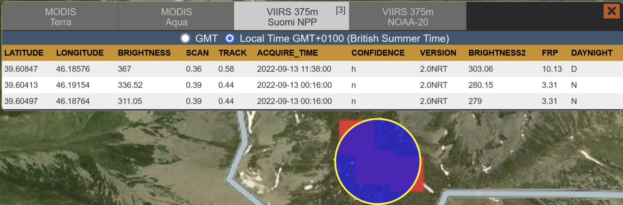
Screenshot taken from NASA FIRMS platform. Fire and thermal anomalies data picked up by satellites indicate there were fires around the area of the incident as early as 3:16AM (local time) on September 13, 2022.
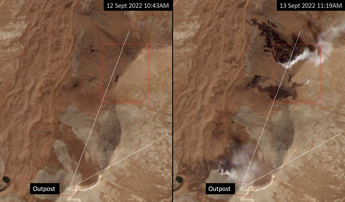
The video reveals what appears to be a darkened area on the side of one of the hills in the background. We matched this dark area with a rocky patch on a peak northeast of the outpost, here:
Screenshot used to represent the approximate view the camera had from the alleged military post where the video was filmed
Screenshot showing marks on a hill located north of the area of the incident. These marks were matched with details featured in the video.
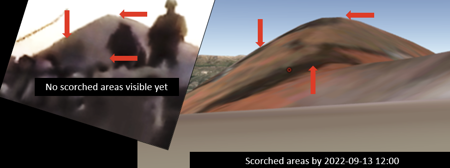
Planet Labs imagery shows there were no scorch marks on this hill on September 12. However, satellite images captured on September 13 do show the existence of active fires and scorch marks spreading over the terrain by midday.
Source: Planet Labs. Date: Sep 12-Sept 13, 2022
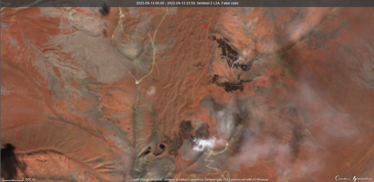
2L2A satellite image with infrared false colour captured on 2022-09-13 at 12:00 (local). Credit: European Union, contains modified Copernicus Sentinel data 2022, processed with EO Browser
Overlaying this Sentinel satellite image on top of Google Earth 3D terrain view, we noticed that sections of these dark marks were already visible on the hill by midday. But none of these seem to be on the video at the time of recording, potentially meaning that the incident took place before this time.
S2L2A satellite image with infrared false colour captured on 2022-09-13 at 12:00 (local). Credit: European Union, contains modified Copernicus Sentinel data 2022, processed with EO Browser. The Sentinel image was overlapped on top of the 3D view of the site using Google Earth Pro CNES/Airbus – Landsat Copernicus.
Additionally, the still images of the deceased soldiers we found on Telegram and matched with the incident were already circulating on September 13 by 11:39 (local time):
Images of dead soldiers which circulated on Telegram. Note the timestamp.
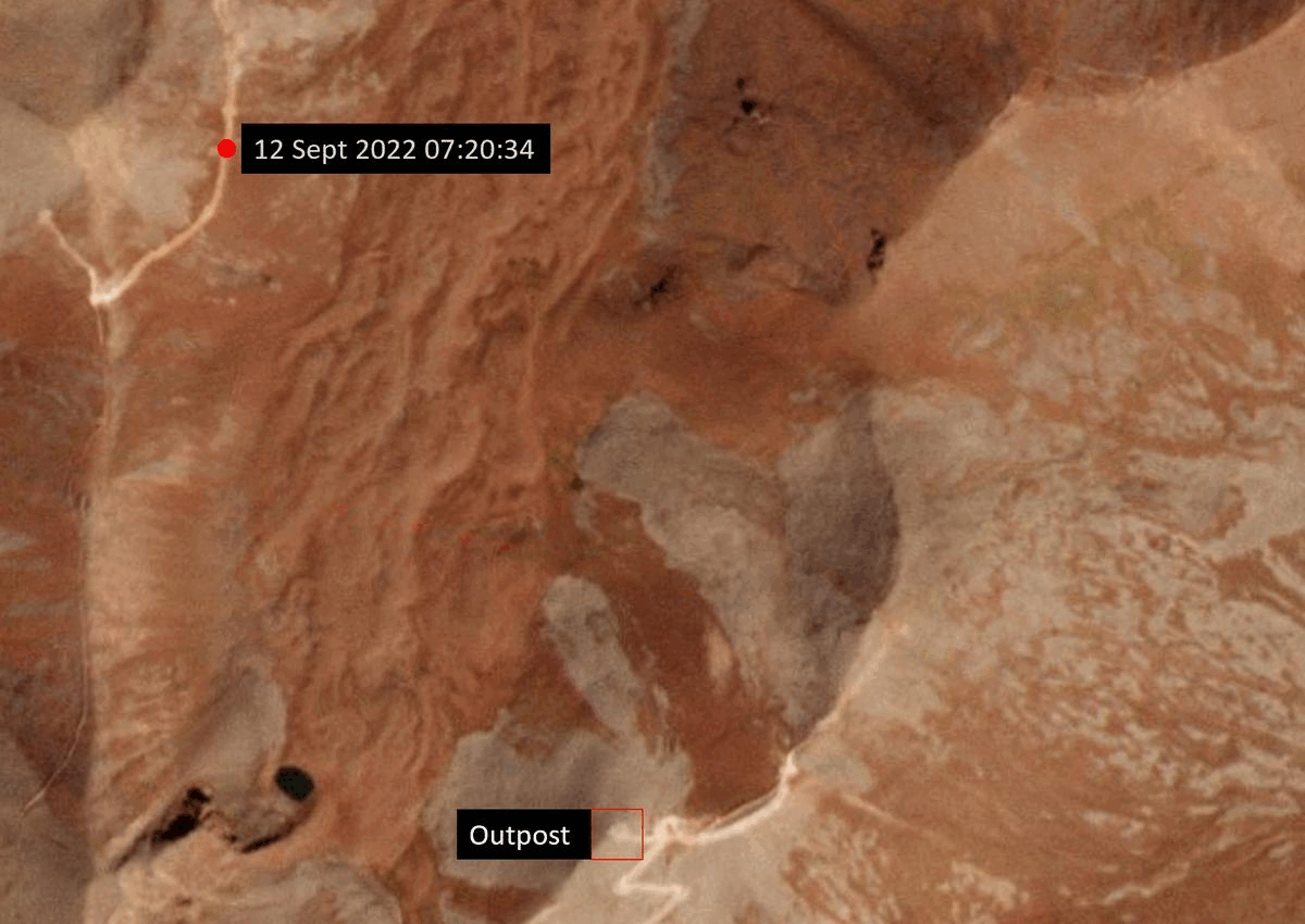
According to historical satellite imagery the outpost (marked in red below) was created between August 15 and 16, 2022. This suggests the location may only have been taken up by Armenian forces in the weeks before the incidents.
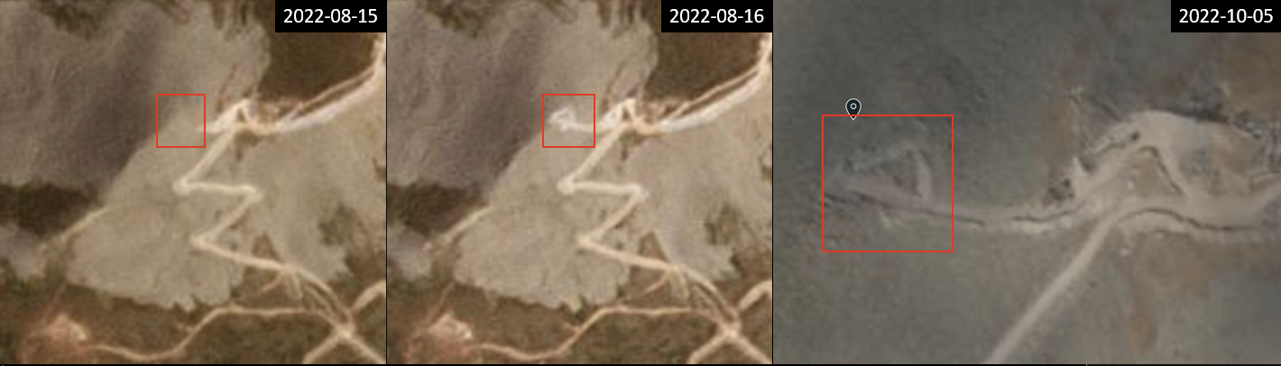
Satellite images show the area of the military outpost in question was created between August 15-16, 2022. The area is still visible as of October 05. Source: Planet Labs Inc.
A more precise time-window can be provided by looking at the sky.
The azimuth and elevation of the sun seen in the footage seems to suggest it was most likely filmed in the early hours of the morning.
We adjusted the contrast and colours of stitched footage frames to reveal a first approximation of the location of the sunrise which can be seen at the middle of the scattered light semi-circumference.
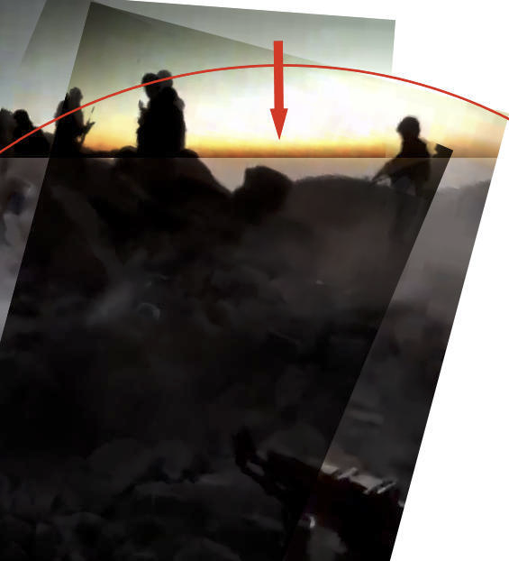
Example of the visual method that was used to determine the position of the sun by changing contrast and colour of the frames. The middle of the semi-circumference gives us a rough estimate of the position of the sun along the horizon. Different measures were taken to obtain an average. Image Credit: Timmi Allen.
Using the Peakvisor platform, we simulated different views and angles until we obtained the best configuration that matched the footage frame selected, here.
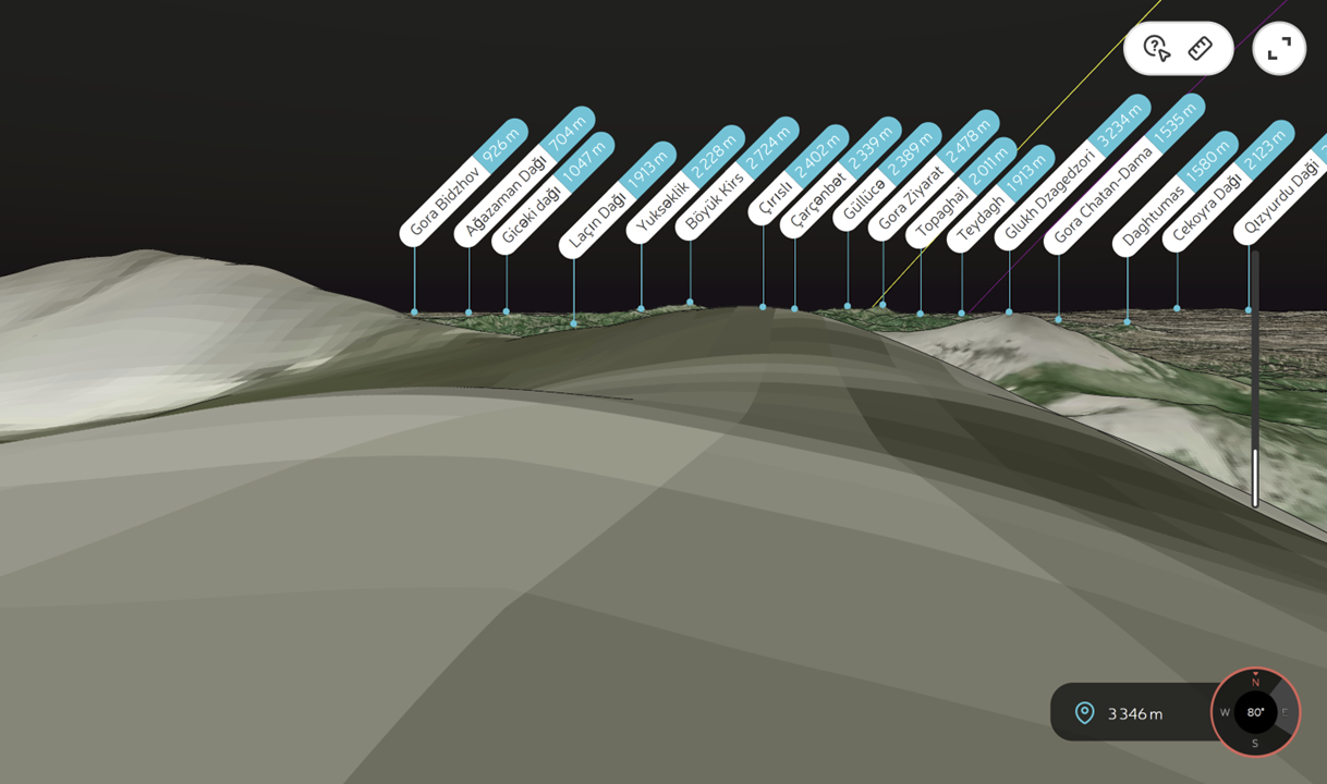
A matching PeakVisor view of the site looking to the northeast.
Every day, PeakVisor displays the sun trail as a yellow line which intersects the horizon at an azimuth angle corresponding to sunrise for each location consulted. According to solar data for the area of interest, sunrise occured at approximately 95 degrees on October 05 (the day Bellingcat carried out the calculation). The view extracted from PeakVisor is oriented towards 80 degrees east. These reference values were used to manually calibrate azimuth lines across the landscape and determine the position of the sun in the video.
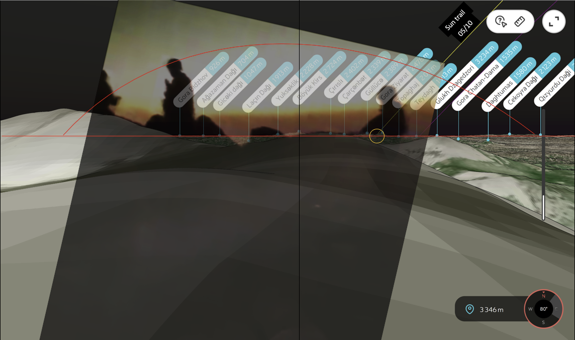
A video frame overlapped on top of the PeakVisor view of the site. Day of calculation October 5. Sun trail yellow line displayed by the platform intersects the horizon at 95 degrees azimuth
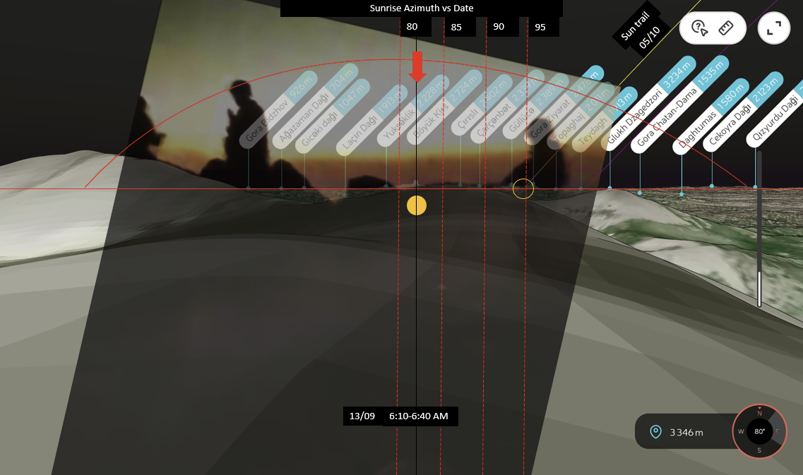
A view extracted from PeakVisor oriented towards 80 degrees east. The sun trail line intersection with the horizon corresponds to 95 degrees azimuth for October 5 (day of calculation). These reference values were used to manually calibrate azimuth lines across the landscape and determine the position of the sun which was located between 80-84 degrees. This sunrise position corresponds to the first two weeks of September according to solar data.
This analysis showed that the video was most likely recorded between mid-August and the morning of September 13 2022.
Our solar calculation indicates that the azimuth seen on the video was likely between 80-84 degrees which is consistent with sunrise azimuths in the first two weeks of September.
For September 13, the azimuth angles estimated with the visual methods roughly correspond to between 6:10 AM and 6:33 AM. according to solar data for this location.
It is important to note, however, that further evidence is needed to determine the exact time of the events. The method above is just a visual approximation and should be treated carefully as a number of factors could affect the calculations (e.g properties of the camera, tilt, software calculations etc).
Following a path
It is also important to highlight that at some point between September 12 and September 13 in the morning, satellite imagery shows tracks began to appear across the landscape through Azerbajiani territory towards the area of the incident.
These tracks were one to three kilometres long and by September 16 they had accessed the area where the footage was filmed.
Time-lapsed satellite imagery showing the creation of tracks between September 12-16. During the morning of September 13 the track’s progress was located here on Azerbajiani territory and was headed towards the site of the incident. Time UTC. Source: Planet Labs Inc.
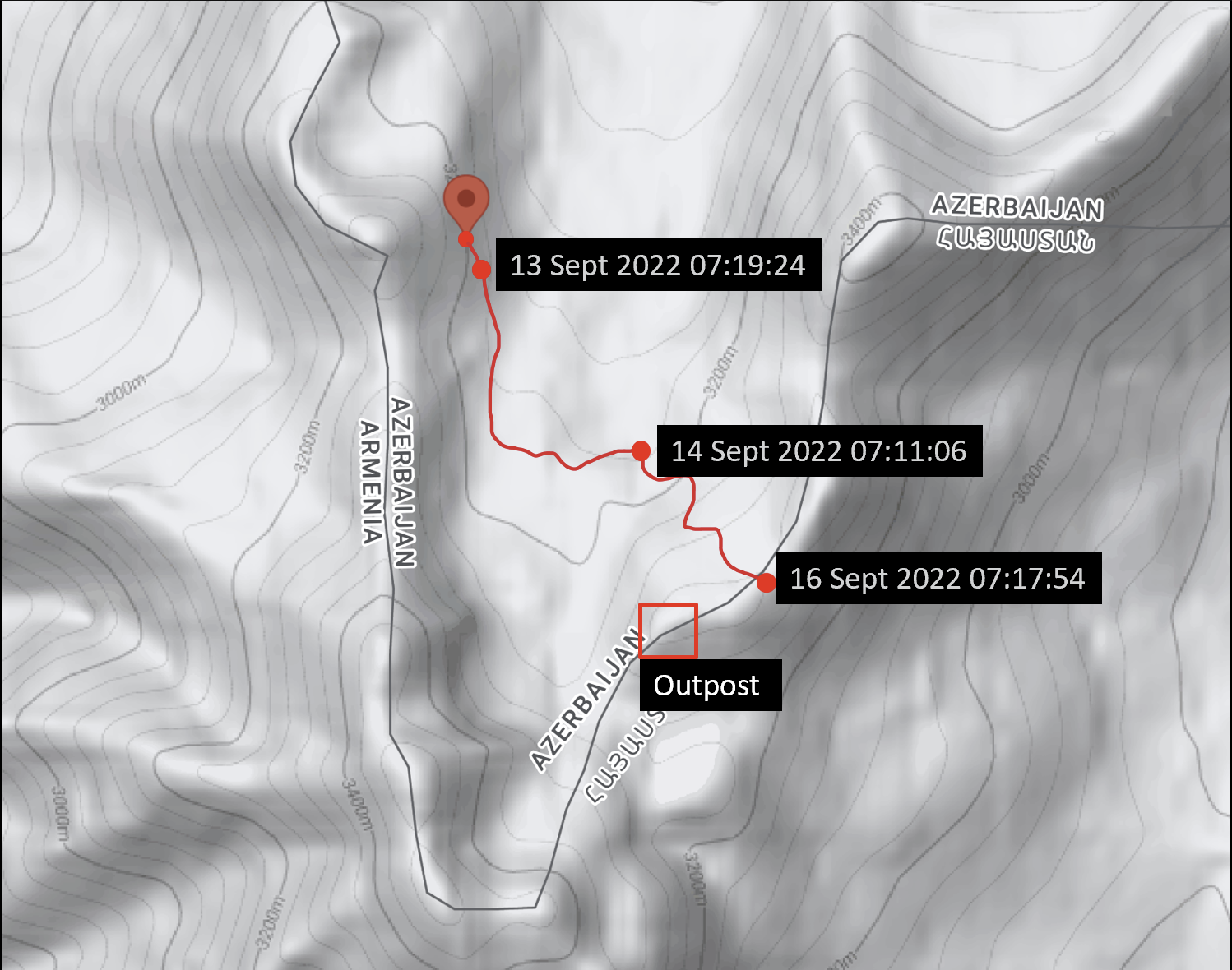
Approximate representation of the tracks. It shows that the tracks were created within Azerbaijan territory. Time UTC. Image: Google Maps
However, It is not clear what these tracks represent or why they appear in the days right after the incident is supposed to have taken place.
Identity of the executioners
A key clue to the identity of the executioners can be found in the audio track of the video. As the armed men approach the group of captives, a voice can be heard saying “don’t shoot!” in the Azerbaijani language. As they open fire at the POWs at close range, voices can also be heard saying, in Azerbaijani, “stop shooting!” This was confirmed by two Azerbaijani speakers who were commissioned by Bellingcat to independently transcribe and translate speech heard in the video.
The speaker cannot be seen in the footage, though their presence suggests that they are of the same unit as the men who executed the prisoners.
Bellingcat also analysed the uniforms and weapons seen in the videos.
The assault rifle used by one of the armed men to shoot the prisoners in front of him appears to be of the AK-74 type, variants of which such as the AK-74M are reportedly produced under license in a number of nations including Azerbaijan. However, the quality of the footage does not allow for a conclusive identification.
As one of the armed men moves closely into view of the camera, the camouflage pattern on his uniform can be seen in detail. A comparison with publicly available military camouflage databases such as Camopedia yielded matches with two similar camouflage patterns (‘arid’ and ‘digital’) of Turkish origin used by the Azerbaijani military in recent years.
‘Since at least 2013, the regular Armed Forces and Internal Troops of Azerbaijan (Azərbaycan Respublikası Daxili Qoşunların) have been wearing Turkish arid digital pattern camouflage uniforms. In some cases, the uniforms and caps are styled differently than those issued by the Turkish Armed Forces, indicating they are not simply surplus Turkish Military issue’, reads the independent website.
“The camouflage pattern worn in the video is predominantly Turkish in origin, often available through surplus sales”, said Ric Cole, a camouflage expert, in an exchange with Bellingcat about the footage.
Azerbaijan and Turkey have a recent history of close military cooperation.
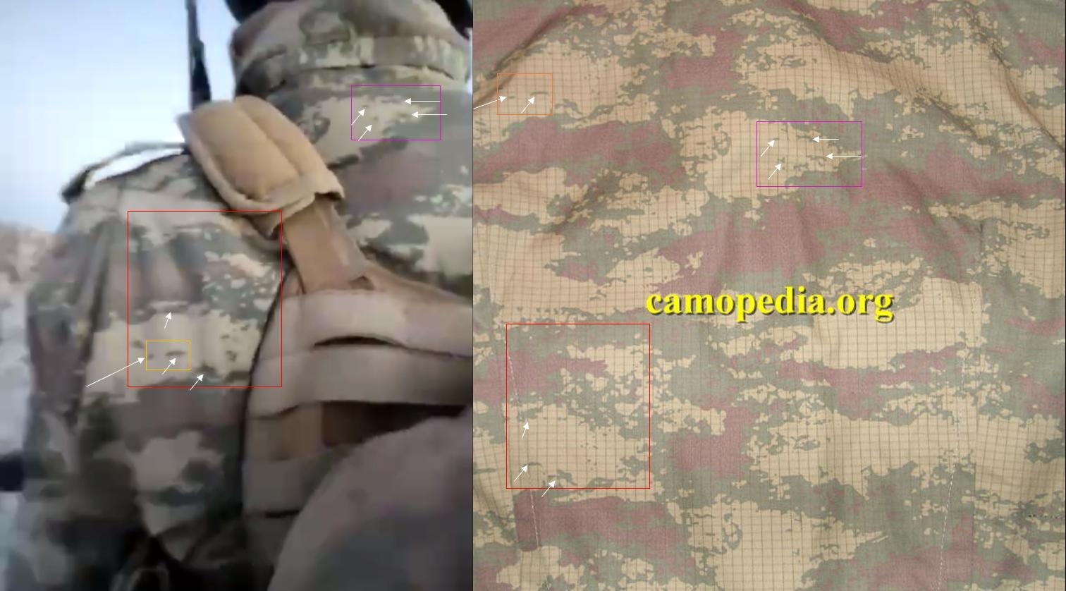
Comparison between armed man’s camouflage pattern and Azerbaijani camo pattern of Turkish origin
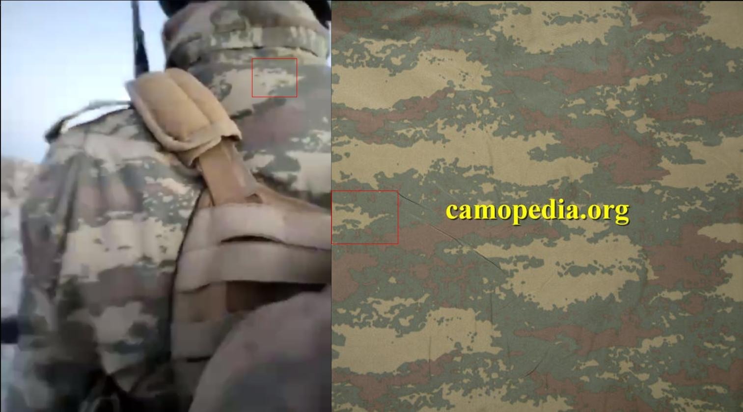
Comparison between armed man’s camouflage pattern and Azerbaijani camo pattern of Turkish origin
When contacted by email for comment, the Press Service of Armenia’s Ministry of Foreign Affairs responded that they believed the Azerbaijani military to be responsible for the executions, but that the unit could not be conclusively established as “camouflage of the military uniforms of the Azerbaijani armed forces has undergone significant changes in these past two years”.
The Armenian ministry’s press service added that human rights lawyers representing some of the victims who have been identified in the footage have already applied to the European Court of Human Rights for the purpose of protecting the servicemen’s rights.
Their Azerbaijani counterparts did not confirm or deny the involvement of Baku’s military in the video, given that an investigation is ongoing.
“As this is an active and ongoing investigation, Azerbaijan cannot comment on specific details at this time”, wrote the Press Service of Azerbaijan’s Ministry of Foreign Affairs in response to an emailed right of reply from Bellingcat, emphasising that pending the outcome Azerbaijan “will prosecute individuals responsible for any violations of law”.
The Azerbaijani ministry’s press service claimed that to date, Azerbaijan has initiated 11 criminal cases against Azerbaijani servicemen for violations of the law during wartime, contrasting this to what it described as Armenia’s failure to “take effective measures to prevent war crimes committed by its personnel or bring perpetrators to justice”.
Bellingcat continues to investigate videos from the Armenia-Azerbaijan border showing possible war crimes committed during the latest escalations.
Editor’s note: This article was updated on December 19, 2022, to note further detail about the location cited in media reports by Siranush Sahakyan.
Carlos Gonzales served as the primary researcher for Bellingcat, with contributions from Timmi Allen, Giancarlo Fiorella, Michael Sheldon and Nick Waters. Special thanks to volunteer Dave Brookes for geolocation assistance. Cavid Ağa and an Azerbaijani translator who wished to remain anonymous provided translations of the audio content.
For this report, Bellingcat acknowledges the use of data and/or imagery from NASA’s Fire Information for Resource Management System (FIRMS), part of NASA’s Earth Observing System Data and Information System (EOSDIS). Please read the LANCE disclaimer for more information about using this data.