Geolocating the MH17 Buk Convoy in Russia
Translations:
Over the last few weeks Bellingcat has been examining footage of a Buk missile launcher filmed inside Russia that matches the Buk missile launcher linked to the down of MH17. The movements of the Buk launcher unit linked to the downing of MH17 were previously examined on Bellingcat, and the reporting relied on several videos of a convoy moving through Belgorod oblast in Russia. Further analysis of the videos yields information which can be used to accurately locate where the videos were filmed.
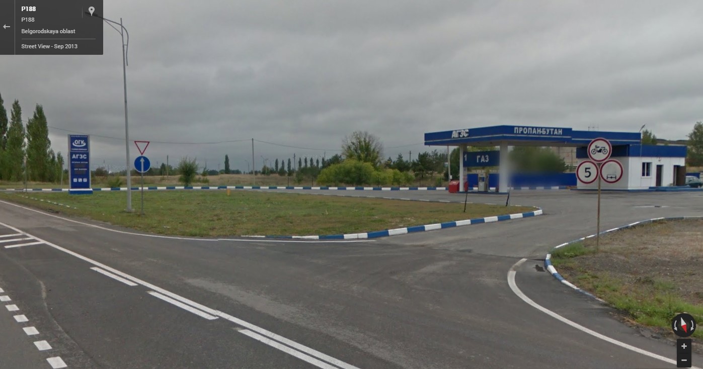
The first video examined was one posted on Instagram, with the location tagged as Neznamovo (Незнамово), south of Stary Oskol and uploaded on June 23rd. First observation upon watching the video is that at the beginning of it the vehicles of the convoy are on a road slightly elevated compared to the vehicles where the video was filmed from, sloping downwards as the clip progresses and finally merging with the main road.
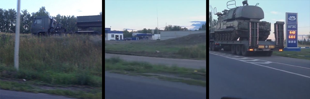
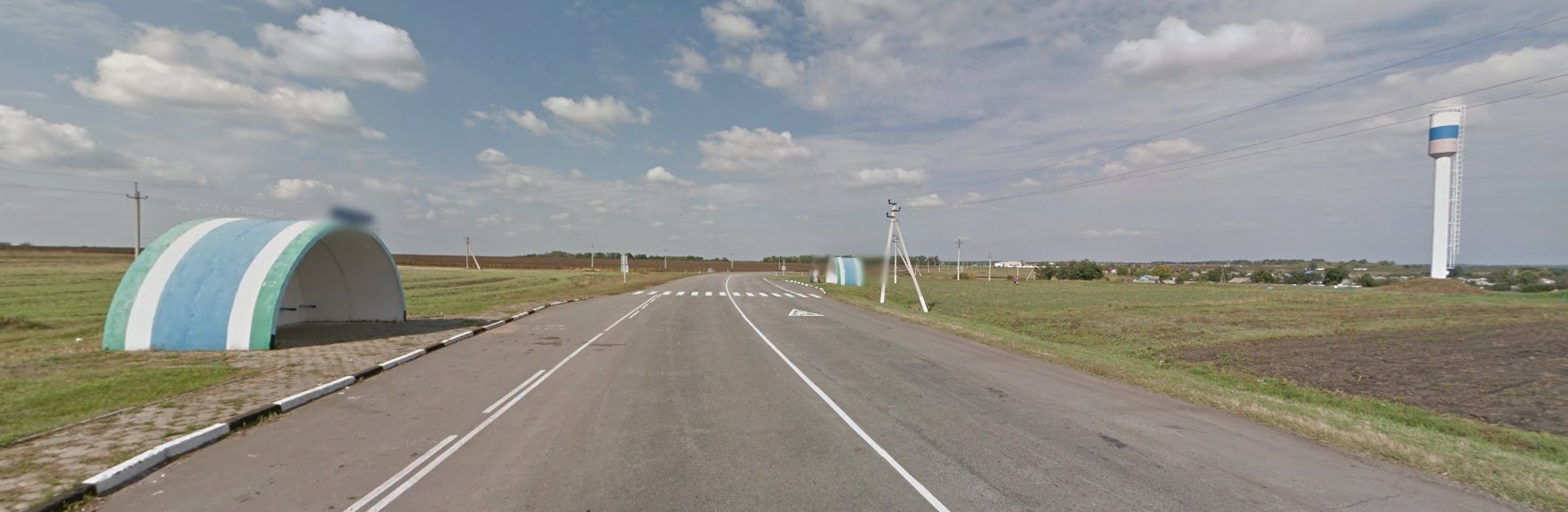
Towards the end of the video, an important clue is revealed: the sign with the letters ‘ОГК’ and ‘АГЗС’, the latter being a Russian shorthand for a gas station. Searching for these terms quickly yields results to the proximity Stary Oskol and Neznamovo, and a Wikimapia link gives us a location where the area features (roads, road markings, buildings) are a strong match to the video. The elevated stretch of the road is an on-ramp to road P-188 heading south. Street View being available for this location, the site can be confirmed with confidence. [Coordinates: 51.233946, 37.940584]
The second video referenced was posted to VK on the morning of June 24th, said to show the convoy in Alexeyevka (Алексеевка), also referencing ‘Magnit’, a major Russian supermarket chain. This narrows down the search area, and section of the road where the trucks are turning give a good reference point to look for in satellite images. A Yandex map search for “Алексеевка Магнит” for gives list of seven locations, one of which is next to a section of road which resembles the area where the trucks can be seen turning.
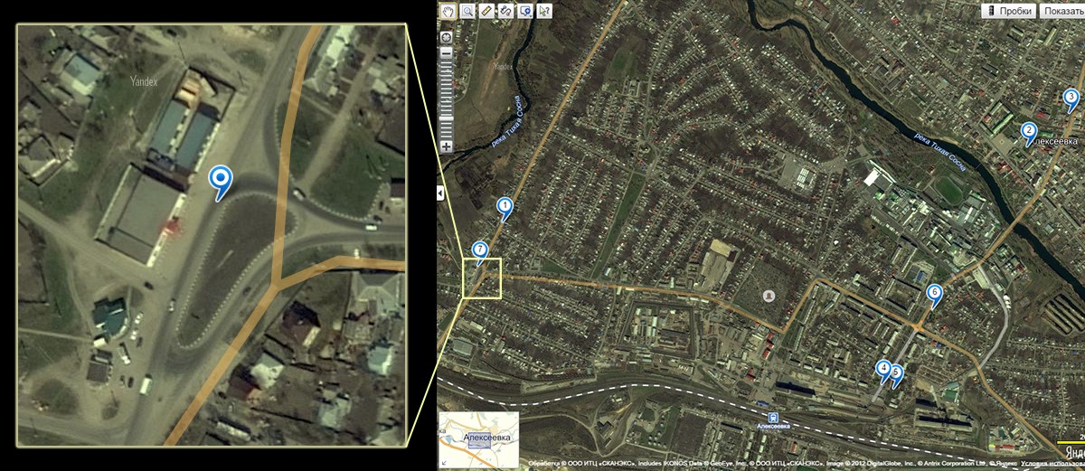
A closer look confirms this location as a strong candidate, as buildings opposite to the reported Magnit location seem like they could match what was shown on the video. Checking Google Maps reveals Street View is available at this location, making verification easy: the location is identical to what can be seen on the video. [Coordinates: 50.624196, 38.649911]
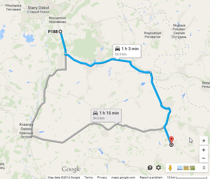
A third video, reportedly from Stary Oskol, seems to have been filmed at dusk or dawn. Viewing the metadata for the video reveals the upload time to be 04:16 ‘Zulu time’, another term used for Coordinated Universal Time, a.k.a. UTC. During the summer months Ukraine is on daylight savings time, meaning the time difference to UTC is +3 hours, so the local upload time of the video has been 07:16 in the morning of June 24th. The video alone provides a few clues about the shooting location, but it’s useful to first look at the other videos to narrow down the search area.
Video number four shows the convoy of vehicles during the daytime, reportedly at Krasnensky district of Belgorod oblast. The scenery in the video appears to show countryside with scarce buildings, but it does offer some details for analysis. First, there are fairly long stretches of straight road, with a curve at around 1 minute into the video. Near the curve, a pair of bus stops is visible, as well as an intersection and a tall structure to the right. Two minutes in, two large structures are visible to the right of the road.
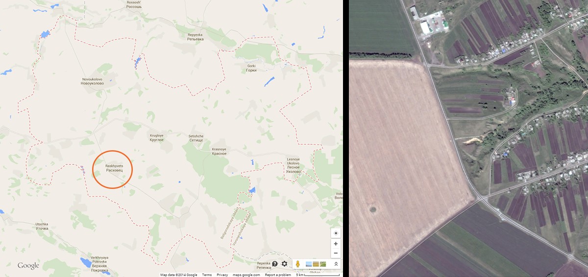
As the Krasnensky district presents a fairly large search area, the road shape gives a good starting point for narrowing the possibilities down. Looking at the main roadways of the area, a stretch of road near Raskhovets (Расховец) appears to be a possible match. Overview satellite imagery also shows two large structures along the road, and zooming in on the satellite imagery of this area reveals two promising details: a pair of bus stops near an intersection, as well as a tall structure casting a long shadow. As there’s Street View images available of the location, these findings can be verified, and the location definitely matches the video. [Coordinates: 50.902533, 38.458406]
As the third video’s upload time was morning on June 24th, it likely was shot sometime between the Neznamovo and Raskhovets videos. With the knowledge of the shooting location of the previous videos, it’s possible to make estimations of the routes the convoy may have taken between Neznamovo and Raskhovets.
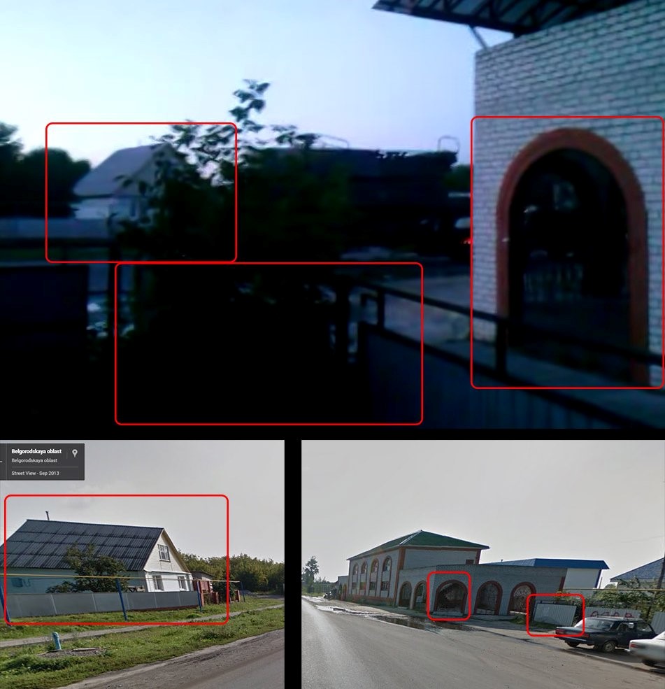
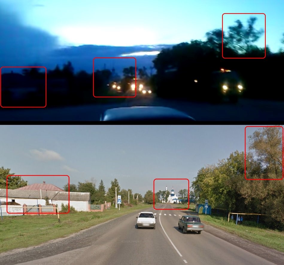
One such suggested route goes through the village of Gorodishche (Городище) in the Starooskolsky district. In the video, some small buildings are visible on both sides of the road, mixed together with trees. Gorodishche matched this description, warranting a further look.
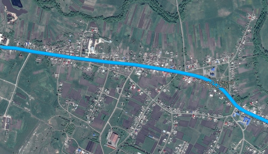
Fortunately, this route is covered by Street View, so a virtual drive-through of the village is possible. One unique feature clearly visible at the beginning of the video is an arch on the building next to where the video was shot, and scrolling through the Street View images, on the east side of the village a building can be found with arches similar to the video. A closer look at the site confirms this to very likely be the shooting location of the video: the fence and buildings on the opposite side of the road match the video, the intersection briefly visible can be seen, and from the frames where the camera is pointing towards the convoy, a nearby church’s dome is visible, with the buildings and treeline also matching the video. [Coordinates: 51.137286, 38.064599]
While not referenced in the published article, Magnitsky had located another video of the same convoy, again from Stary Oskol. The video is fairly short and shaky with lots of panning, but the units are clearly identifiable. With the footage, it was possible to create a rudimentary panorama to get a better sense of the overall area where the video was filmed.
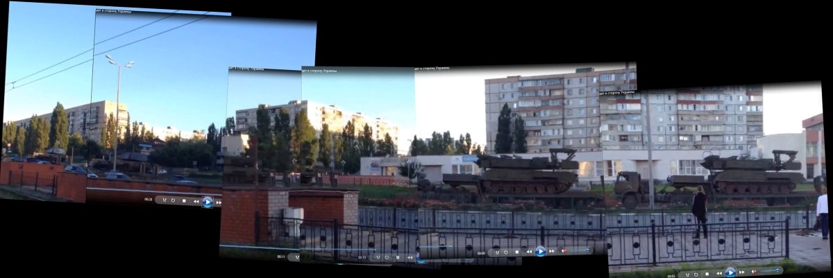
From the footage, a few key details stood out: on the very left of the scene, rails and cables are visible. This seemed to indicate the footage might have been filmed near a light rail or tram station. English Wikipedia confirmed that there was one operating in the city, and Russian Wikipedia provided more details on this. It became apparent the Stary Oskol light rail operated on a single rail line, so checking the assumption would be fairly simple: find the end of the line, and follow it down to see if there are any matching locations.
Following the rail line south, a location can be found on Street View where the brick wall and the building on the right appear to match the video. Further orienting the camera confirms the features match the site exactly, with the video seemingly filmed from the light rail station. [Coordinates: 51.311605, 37.897013]
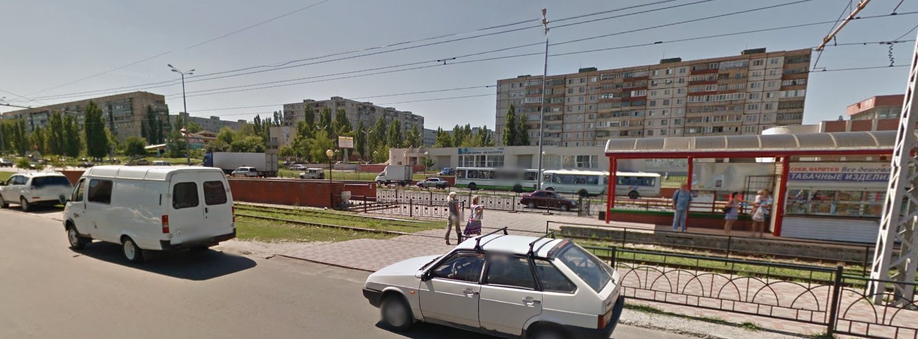
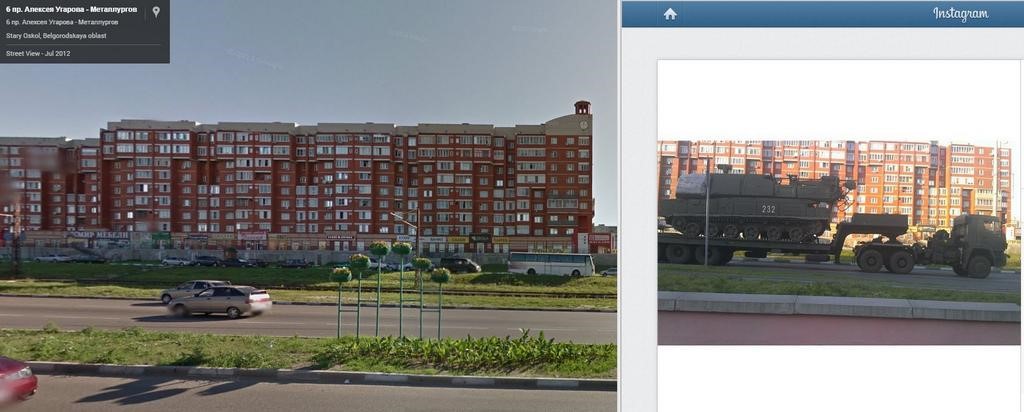
Exploring the city streets on Street View also gave an indication that the Instagram image of the convoy might be from along the same route. In fact, the picture can be located to approx. 1km of the previous video, based on the red apartment building and pavement features. The picture appears to have been taken from the Eldorado store parking lot. [Coordinates: 51.323770, 37.882489]
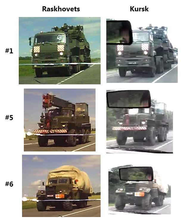
Further searches for additional material from the same dates has uncovered another video from Kursk, reportedly from June 23rd, the same date the convoy had been filmed passing through Stary Oskol. The dashcam video is of poor quality and many details are not visible, but composition of the convoy gives a strong indication this may indeed be the same one. In fact, compared to the convoy seen near Raskhovets, the first 16 vehicles seem to be in the same order.
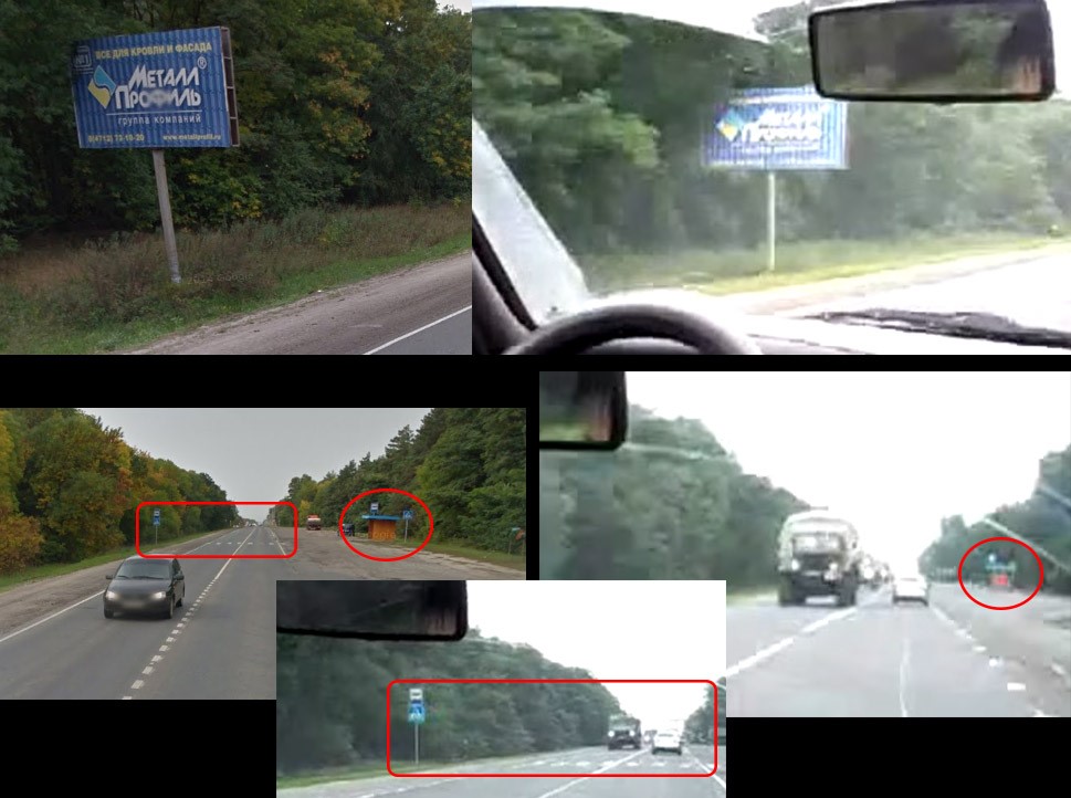
To locate this video, there are a few clues: reported location (Kursk), treelines on both sides of the road, a large blue sign on the side of the road, a crosswalk and a small reddish object on road’s wide shoulder on the right. From overhead satellite imagery, it can be seen that the road A144 on the east side of Kursk is lined by trees, and zooming in on this area further reveals crosswalks on this road. One section of this road has a wide shoulder near an intersection, and having a look with Street View again reveals matching details: a wide shoulder as in the video with a dark orange colored bus stop and a crosswalk next to it, and looking in the opposite direction a big blue sign on the side of the road. [Coordinates: 51.722592, 36.336530]
Putting all these data points together we can plot these points on a map, which would fit on a possible route from Kursk to Alexeevka. Compared to the shortest routing suggested by Google, only one manual adjustment to the route has been made in Stary Oskol, which adds 1km to the route, but avoids smaller roads and turns. The green markers show the locations at which the BUK unit had been filmed as part of the convoy, and the yellow markers show where other vehicles of the same convoy were filmed.