With the release of the Dutch Safety Board report into the downing of Flight MH17 it is now possible to compare the evidence gathered by the Dutch Safety Board with claims made by the Russian Ministry of Defence in their July 21st 2014 press conference on the downing of Flight MH17. In Bellingcat’s “Russia’s Colin Powell Moment – How the Russian Government’s MH17 Lies Were Exposed” four claims made by the Russian Ministry of Defence during the press conference were examined and shown to either be lies, fabrications, or both. While the Dutch Safety Board report does not cover all aspects of the Russian Ministry of Defence’s July 21st press conference it was still possible to compare the Dutch Safety Board’s conclusions to some of the claims made by the Russian Ministry of Defence.
MH17’s Flight Path
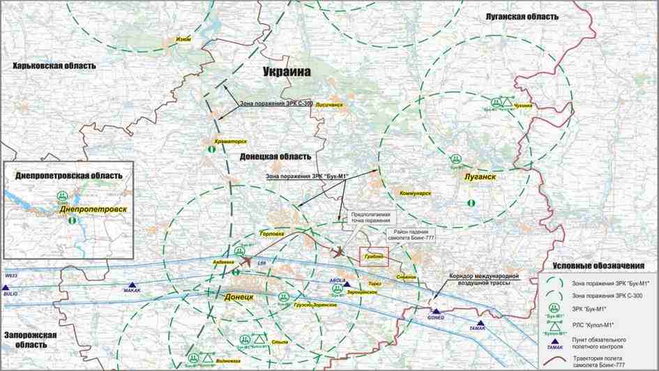
One of the Russian Ministry of Defence’s key claims was that MH17 had been redirected out of its flight corridor, making a significant turn clearly visible on the image they presented of MH17’s flight path, shown below:

Data from the preliminary Dutch Safety Board report published on September 9th 2014 showed that this claimed flight path was a fabrication, with the following comparison created by Bellingcat clearly showing the difference between the Russian Ministry of Defence claim and the Dutch Safety Board’s findings in their preliminary report:
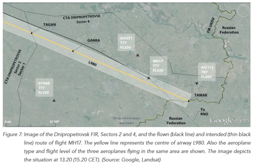
The below map is from the final Dutch Safety Board report showing the route of Flight MH17, which confirms the route published in the preliminary Dutch Safety Board report:

This is final confirmation that the Russian Ministry of Defence presented a fake map of Flight MH17’s flight path in their July 21st 2014 press conference, and lied about the flight path during the press conference.
The Ukrainian SU-25 and Radar Data
The Russian Ministry of Defence presented the following image, which they claimed represented aircraft in the area at the time:

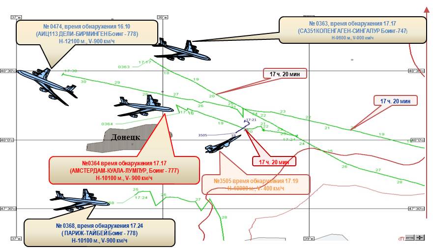
The Russian Ministry of Defence then stated the following:
At that time there were 3 civilian aircrafts:
Flight from Copenhagen to Singapore at 17.17;
Flight from Paris to Taipei at 17.24
Flight from Amsterdam to Kuala Lumpur. Besides it, Russian system of air control detected the Ukrainian Air Force aircraft, purposed Su-25, moving upwards toward to the Malaysian Boeing-777. The distance between aircrafts was 3-5 kilometers.
The Russian Ministry of Defence also presented a video of what it claimed was radar data showing aircraft in the sky at the time:
They then stated the following:
At 17.20 P.M. at the distance of 51 kilometers from the Russian Federation state boundary and the azimuth of 300 degrees the aircraft started to lose its speed obstructively which is quite distinctively to be seen on the table of the aircraft characteristics. At 17.21 35 seconds P.M. with the aircraft speed of 200 km/h at the point of the Boeing crash there is a new mark of the aircraft to be seen. The aircraft was steadily monitored by radar stations of Ust-Donetsk and Butirinskoe during 4 minutes period. Air control officer having enquired the characteristics of newly appeared aircraft couldn’t possibly get them because it is in all likelihood that the aircraft had no secondary deduction system amounted on it, which is put typically for military aircraft. The early detection of this aircraft appeared to be quite impossible because the air situation control is usually performed by radars working in a standby mode which detection possibilities at the given distance are over 5000 m altitude.
As part of the Dutch Safety Board investigation radar data was requested from Ukraine and Russia, with the results of the requests detailed in section 2.9.5 of the report:

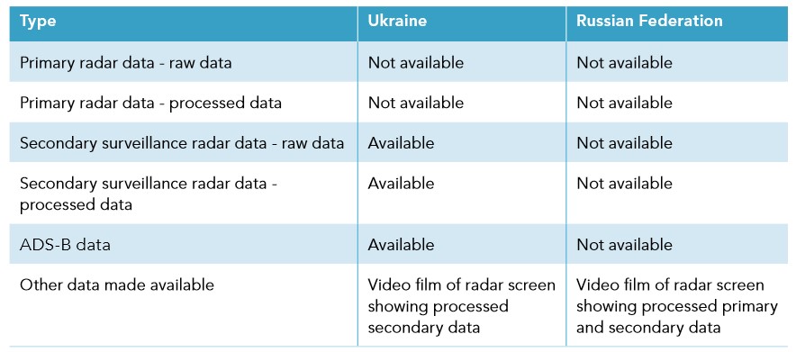
Russia was unable to provide any of their raw or process data, only providing a video of the radar screen showing what they claimed was processed primary and secondary data. The Dutch Safety Board states in section 2.9.5.3

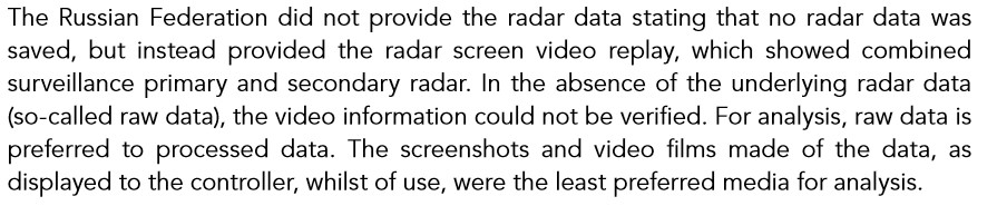
Russia claims its data retention policies resulted in the data not being stored, and this is examined in detail in section 2.9.5.3 of the report. Regardless of regulations, and whether or not Russian followed them, it seems extremely odd that a few days after the downing of Flight MH17 Russian would use this data as part of its MH17 press conference, but not save a copy of the data for the Dutch Safety Board investigation, or the criminal investigation.
However, based on the information presented by Ukraine and Russia the Dutch Safety Board was able to come to a conclusion about other aircraft in the air at the time MH17 was shot down. In section 3.4.2 it referenced the second object that appeared on the radar, identified as an aircraft by the Russian Ministry of Defence:

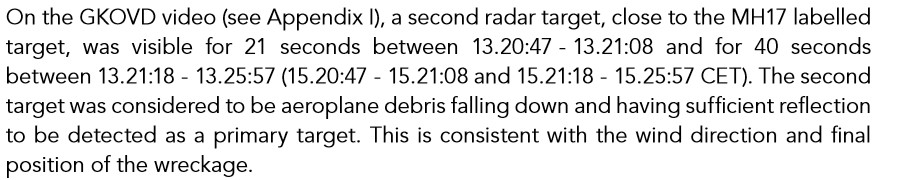
The Dutch Safety Board made the following conclusions on the presence of other aeroplanes near Flight MH17 in section 10.2:

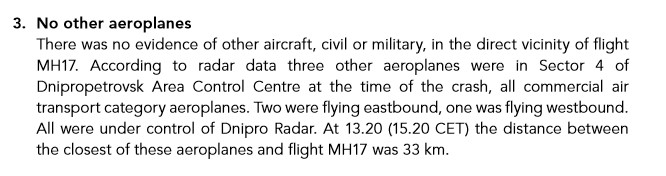
In conclusion, it is clear to see that the claims of the Russian Ministry of Defence of an SU-25, or other military jet, close to MH17 were totally false, and they purposely misread radar data (also examined by other experts who came to the same conclusion as the Dutch Safety Board) to support their false claim a military jet was near to Flight MH17.
In addition to the above claims made by the Russian Ministry of Defence in their July 21st press conference it has been previously possible to prove the Russian Ministry of Defence lied about three other key claims, detailed here. It is now clearer than ever that the Russian Ministry of Defence’s reaction to the downing of Flight MH17 was to create lies and fabrications and present them to the world, only days after Flight MH17 was shot down, killing 298 people.
There is a typo in the report:
“On the GKOVD video (see Appendix I), a second radar target, close to the MH17 labelled target was visible for 21 seconds between 13:21:47 – 13:21:08 and for 40 seconds between 13:21:18 – 13:25:57”
If I have understood the video correctly that should be between 13.21:18 and 13:21:17. A period of 60 seconds.
Time Alt speed
13:20:31 33000 907
13:20:41 33000 898
13:20:49 33000 593
13:20:55 33000 443
13:20:59 XXXX 363
13:21:00 XXXX 320
13:21:09 XXXX 320
13:21:17 XXXX 319
13:21:21 XXXX 282
13:21:31 XXXX 248
13:21:43 XXXX 220
13:21:51 XXXX 211
13:22:00 XXXX 204
13:22:12 XXXX 202
Meant to add, it could well be debris. There seems to be a considerable lag, as other sources say the data flight recorder stopped at 13:21:03. Whereas according to Rostov it’s transponder was sending an altitude signal until 13:20:55 (perhaps the software just uses the last received signal for some seconds?)
Either way according to Rostov because of the distance their primary radar wouldn’t detect anything under 5000 meters: “The early detection of this aircraft appeared to be quite impossible because the air situation control is usually performed by radars working in a standby mode which detection possibilities at the given distance are over 5000 m altitude.”
So a Su-25 flying quite slowly between 5000 m and its ceiling at 7000 meters? Or debris falling from 10000 meters to 5000 meters. On reflection I think Rostov may have over-interpreted the data
In any event, the responsibility for providing primary radar for this crash was Ukraine’s. A responsibility that they were unfortunately unable to fulfill as their civilian primary radar was undergoing scheduled maintenance and their military primary radar team – supremely confident the Russians would never dream of violating their air space – were having a little nap at that exact time the crash took place.
Dude…u keep talking about a SU25…but if all agree a BUK caused the crash what’s the point of this second plane ?
ignore my comment pls
So are you saying the 13:21:08 should be 13:22:08 ???
In order to make the difference between 13:21:47 and 13:22:08 actually 21 seconds?
If this is what it states, then I think your right it is a typo to be edited.
The second set of numbers I think you made a typo on.
I do not see the difference of 13:21:18 and 13:21:17 being 60 seconds.
And similar to the above statement, 13:21:18 – 13:25:57 probably should reflect – 13:21:18 – 13:21:57 to reflect ~ 40 seconds.
Maybe you did find some typos, but I think you made one yourself 😉
Wonder why the RF did not inquire about this in their 60 day period of review?
But they can spend millions of rubles on a warhead detonation simulation that gives some good interesting public results but some false ones as well.
I have not read through that part yet, I am a slow reader, so I am just taking your comment at face value.
Fare thee well
I’m not familiar with this website. Would I be right in thinking it’s predominantly pro Washington? That would be a pity. I’m a non-aligned seeker of truths and an observer of the human condition, and have no wish to tangle in unseemly ways with armchair generals or fanatics of any political or religious hue. Adult mentality and rigorous intellectual integrity are virtues I’d welcome in discussions here. If on the other hand this site is all about working backwards from preselected conclusions in order to furnish ‘supporting evidence’, then of course I’ll go elsewhere and leave the ‘fearsome warriors’ to it.
Two questions pester me about the MH17 affair after I read the Dutch report and annexes, watched two big press conferences by Almaz-Antey, and perused various other public sources on MH17 thus far.
1. John Kerry was so sure that data from (unspecified) US “sensors” showed the trajectory of a missile launched against MH17, but the US still hasn’t published that data, as urgently requested by the Russian Ministry of Defence. Why?
2. Why has the Dutch Safety Board rejected the conclusions drawn from the latest simulations and physical experiments conducted by Almaz-Antey which indicated a very different angle of attack of the missile (and hence probable launch site), compared to that preferred by DSB and their other technical consultants? And what exactly is wrong with the evidence of Almaz-Antey’s physical experiment that shows a very significant absence of fragmentation hits on the area of the port engine when an SA11 missile has the angle of attack preferred by DSB? And what exactly is wrong with Almaz-Antey’s latest simulation that shows a very different angle of attack compared to that preferred by DSB, and yet yields a pattern of frag damage apparently very consistent with the actual Boeing damage, including on the tail, port wing and port engine duct? From this ‘alternative’ angle of attack of course a different probable area of missile launch is derived. I’d like to trace which of the warring parties was in possession of that ‘alternative’ probable area of Buk launch on the tragic day, but I bet (and hope) some of you citizen detectives will beat me to it!
The arguments were never put to the DSB. Firstly Almaz only publicised their arguments on the morning of the release of the report and whats more did not submit them for consideration in the report, nor did they invite observers to the “experiments”. So to suggest the arguments were rejected is disingenious.
What’s more if they are attempting to replicate what takes place at 33,000 feet 10 feet off the ground and not even replicate the (supposed angle) of detonation you are pretty much on a hiding to nothing.
It would also appear that no military from either side were in the area of the alternative launch site on the day in question. According to eye witness accounts, which given the lack of any other evidence on this area in the public domain on this area, is the only evidence available, there was no military presence.
https://www.youtube.com/watch?v=hdKzEKe76co
But seeing as you are a seeker of truth and observer of the human condition. Perhaps you could solve this one for me?
Why would the Ukranian military fire their very first anti aircraft rounds of the entire conflict at a plane headed east?
Doesn’t quite tally up does it?
No Salazar, it doesn’t tally up; nor does much of this whole affair. But haven’t we encountered this this extraordinary degree of mystery and puzzlement elsewhere, the Maidan sniper attack, for example? It is partly for this very reason – ie that things are so far from tallying up – that I would expect the international criminal investigation to include a false flag attack as one of the possible scenarios. But, well, I won’t be holding my breath.
As for the most recent Alamaz-Antey findings, yes I read DSB’s complaint that the Russians hadn’t fully complied with the protocols expected in major accident investigations, and perhaps the Russians did themselves and the whole investigation a disservice by doing things in their own, somewhat idiosyncratic way. Nevertheless, to ‘disqualify’ (if that term is admissible) the totality of these important new Russian findings on such grounds appears disingenuous if not grossly biased. We’re not dealing with the clerical niceties of an alleged parking violation here. Also, and correct me if I’m wrong, I recall that Almaz-Antey mentioned in their public presentation on 13th October in Moscow that their new findings had not been accepted by the official investigation (or some such wording) – meaning of course that they had notified DSB of their new findings prior to 13th Oct.
Do you have professional experience of weapon system simulations? If you have, as I have (8 years, and at that time my company had Europe’s most powerful realtime weapon simulator), I’d be happy to discuss with you the pros and cons of the various simulation studies in the MH17 case. Otherwise I’ll just say that from what I’ve seen in their presentation, Almaz-Antey’s simulation studies appear wholly worthy of further examination with a view to inclusion and consideration in the official investigation – perhaps warranting an update of the DSB report. Since we don’t know what information the US or others might introduce into the criminal investigation, surely we have to assume for the time being that the issue of the missile’s probable launch area, as derived by simulation studies, is germane.
RealityBud,
The Kremlin got their copy of the FINAL DSB report for review and questions and adding items if they wanted on JUNE 2 2015.
They had 60 days to submit and discuss anything in the report or attempt to challenge it in any way they wanted.
June, July, August 2 was their final day for saying hold up, this is wrong or we are doing a test or we finished a test and here are the results.
They had almost a whole year before June 2 to design and plan a test and do it for the RT audience.
They did not.
They did their test October 7 2015
That is what disqualifies any of their results and it is not with bias or anything.
As far as the weapons simulations, DSB really did not need those results for its mandate.
And the test they did would be just the early preliminary testing done buy the JIT group.
There will probably be tens, if not hundreds, of 9N314M warheads blown up.
A-A did nothing more then some computer simulations, a static warhead test with a bunch of Flat (not curved) aluminum panels, and a test with a front part of a static plane,
The figures and data might hold some relevance, but they fall far short of the actual testing that will be done in this case.
It will be nice to confirm what is in old Soviet manuals that JIT has from Finns and Egypt and Iraq I believe and some of their testing.
A – A just did what JIT will be doing in early stages.
And not doing them before August 2 just shows what a shame and disregard the RF has for the international community and their forensics abilities.
AS far as the closing of airspace.
The BUK has many safeguards built into it that would allow identification of civilian aircraft and avoiding the destruction of one.
About a hundred flights overflew the region that day.
The Separatist had not yet shot down or destroyed any civilian aircraft previously.
A BUK is not like some RPG that you point and shot and if it may miss an aircraft it will retarget another.
The missile blows up if it misses its intended target.
Ukraine acted responsibly with the intelligence it had, and a working BUK system was not noticed before then or one with missiles loaded on it.
They were actively searching as the images released prove.
If your going to blame Ukraine about not closing airspace, then I guess your the type of person that blames a woman for not wearing a Burka that gets sexually assaulted.
As far as the shadowing, what do we have for proof?
The GF of a known POW executioner on a YouTube clip stating it, and Kremlin sponsored media propaganda outlets repeating it, that is it.
There is no proof it happened, and I would welcome you back that claim up with some ACTUAL documented proof in order to make that claim.
So far, I have not seen it.
The Russian MoD has not provided any proof, so the claim it happened is not backed up by more then just a YouTube clip of a mass murdering criminal’s girlfriend and now wife.
Please provide proof of your idiotic reiteration of Kremlin propaganda lies.
Fare thee well
John Kerry was so sure that data from (unspecified) US “sensors” showed the trajectory of a missile launched against MH17, but the US still hasn’t published that data, as urgently requested by the Russian Ministry of Defence. Why?
Because it now forms evidence in an ongoing criminal investigation and as such needs to be considered in concert with other evidence.
Here is a question. Why did the Russian Federation lied in regard to the Flight path of MH17?
What’s more given that we are discussing the publishing of data, do you both think it a little rich that the Russian Federation are urgently requesting other countries publish theirs, when Russia has deleted and failed to supply any radar data of it’s own?
Please believe me, I’m not a fan of Russia’s obfuscations, craftiness, defensiveness and sometimes arrogant and bellicose attitudes where these appear incongruous or unnecessary. I do wish to God they’d calm down more. But I also try hard to understand their position. And I notice, approvingly, having played a part in the Cold war for many years, wherever I see today’s Russians successfully departing from the old totalitarian mentality. But yes, it’s a long, slow and painful process of change – perhaps impossible for many in the older generations.
MH17’s flight path reported early on by the Russian MOD does indeed appear to clash egregiously with that shown in the DSB report. But are we being Professor Hindsight here? My guess is, the Russian general believed at the time that MH17’s flight path was at its worst 14 km from the corridor edge. But this early information, and that of multiple radar targets momentarily appearing on Rostov’s ATC display, was patchy and very likely to have provoked some rough and ready military thinking.
After long analysis and consideration we now know much more, such as the break up of the Boeing into a few large parts that took various different descent paths and may well have given rise to the ‘nearby bogey’ radar returns. As to why the Russian general thought MH17’s deviation from the corridor was up to 14 km, I still don’t know, but I’m not going to presume he was simply lying.
One hypothesis that persists for me is that Kiev didn’t entirely close their airspace to commercial traffic because they hoped or expected their enemy would be very careful not to shoot innocent aircraft out of the sky, thus commercial traffic would provide a convenient human shield for Kiev’s military air traffic. And the Russian MOD, being well aware of this cowardly and cynical stratagem, would have been furious to see a commercial flight ‘dangled over the balcony’ Michael Jackson style; (1) because it was running a huge risk of – perhaps even inviting – accidental shoot down under normal rules of engagement, and (2) because it could be seen as moving the cowardly human shield even farther into the combat zone to protect some military air operation of Kiev’s. If you were a Russian general and furious and disgusted at Kiev’s behaviour, whilst also knowing full well how mainstream pro-Washington media were going to deal with this grievous event, then you too might not have stopped to split hairs endlessly and recheck all the rough and ready information such as 14km max deviation from the air corridor. Hey, it’s a working hypothesis, that’s all.
Yes this website is pro Washington.
Max van der Werff has discovered that a bridge on the way into Torez on the supposed Donetsk/Torez Buk route is too low for the truck and Buk to pass without unloading the Buk.
So I guess they unloaded it, loaded it again, drove into Torez, then unloaded it again.
maybe support your statement with a link…
video.
So I guess they unloaded it, loaded it again, drove into Torez, then unloaded it again.
Why? The Photos of the BUK in Torez show the BUK on its own, having been unloaded, quite why you think this video means that they reloaded the BUK and drove the truck in to Torez I don’t know, especially given you can see it going under it’s own power and there has never been any mention of the truck in Torez.
Or do you think this is like a stair case to a Dalek? Sorry lads it won’t go under the bridge. Take it back…
no, the photo of the Buk in Torez shows it on a truck.
cool, i see a bridge on a road with a heigt marking…and somebody put there some math calcs…
1 – is the marking correct and matching the actual size of the bridge? You know…maybe the sign 4.7m has never been produced or something else…
2 – is this the only road on which buk is supposed to have travelled?
3 – Can the height of the truck+buk be verified?
4 – If u look in google maps, even if we don’t have street view, you can see that there is a road bypassing the bridge about 250m western and 100m eastern the bridge…
As always check BY YOURSELF and don’t belive as god to a video 😉
https://www.google.it/maps/@48.0331773,38.5672677,442m/data=!3m1!1e3
better talk to bellingcat about it, not me. they think it went under the bridge somehow.
Where do they say it passed under that bridge?
I showed you (and via the link u can see by yourself) that there is a secondary road bypassing that bridge…
So if anyway the buk was too high to pass under….it can use the secondary road 😉
you cant bypass it. the main road is too deep for that.
too deep for what?
The road is actually going down and after the bridge it starts going up: the bridge it on the ground level, the main road has been digged…
Check before making claims 😉
look this picture
https://www.google.it/maps/@48.033287,38.568234,3a,75y,90t/data=!3m8!1e2!3m6!1s117931563!2e1!3e10!6s%2F%2Fstorage.googleapis.com%2Fstatic.panoramio.com%2Fphotos%2Fsmall%2F117931563.jpg!7i4000!8i3000
Its like that problem you have with things crossing borders Randy. you see it on one side of the bridge, you see it on the other side of the bridge. Logic dictates the rest.
It went under the bridge, over the bridge or around the bridge. Which one doesn’t really matter.
Wow Randy, now I think you have bad eyesight. There is a substantial access road that goes around the railroad bridge, and to the left it services another main road and to the right it bypasses the bridge and also services a substantial facility. Anyone familiar with that area would take that access road. Of course, it these were Russians driving, anything could happen as we saw with those series of photos/vids on the Russian convoy (how many times did they get lost and have to make a U-turn in the middle of some town. This one seems pretty easy to solve unless one want to continue a policy of discrediting.
Do Bellingcat have any answer for this?
you so called road goes through several trees.
if its even passable for an ordinary car, there’s no way a massive vehicle like this would make it.
Are you a truck driver? … they can do miracles … i’m serious, watch them driving!
There are no sharp turns, the road is plain, is asphalted, trees are on just one side and don’t seem too dense, it doesn’t seems a single way road …
And #1 point is still to be verified: the actual height of the bridge…wanna go check ?
look in this other picture, u can see better the road
https://www.google.it/maps/@48.033302,38.5667959,8a,31.1y/data=!3m8!1e2!3m6!1s117931559!2e1!3e10!6s%2F%2Fstorage.googleapis.com%2Fstatic.panoramio.com%2Fphotos%2Fsmall%2F117931559.jpg!7i4000!8i3000
that picture is the main road not your phantom side road.
the road is not asphalted, it cant be because there are trees growing on your phantom road.
look around on the map, there are imaginary roads like that all over the area that go nowhere.
And in google heart’s picture you can see a big factory/warehouse serviced by that road….do you still think that it’s so small?
look at your fantasy road where it ‘rejoins’ the main road.
there’s nothing there. it goes through trees.
No, in the original photo you can see the asphalted road coming back in to join the main road. Get real Randy!
No trees involved at all. I think you are looking at one of the road views at the bottom of one of the Google screens, but that is not what we are talking about.
No more stupid claims to be made RANDY?
Then i can go to have dinner … bon appetit 😉
RANDY Are you serious?? Use your brain and look on the left side of those pictures, behind those trees you can see a road that is asphalted for sure…
Trees can grow aside asphalted roads, you know ? need few pictures as proof?
You belive that trees next to a road prevent it to be asphalted ?
As i said before…you posted a video trying to demonstrate something… now can you say us exactly the height of that bridge? NO … so u can’t demonstrate anything
If you have troubles with those lines drew by google maps i’ve a little help from you…
Just saved by me from google earth
http://s9.postimg.org/obca09s33/image_for_randy.jpg
Look where your ‘road’ rejoins the main road.
there’s nothing there.
and there’s something else in the way.
what is it that goes across the bridge on the main road?
railway
yes its a railway. it cuts right across your imaginary road.
how does it cross your road? bridge?
I go to the mountain every winter and i cross a railway with my car… so does anyone who passes trucks too, coaches too !
Here is where it is…
https://www.google.it/maps/search/maps/@46.0419247,9.3038808,105m/data=!3m1!1e3
NOTHING….and why google bothers drawing a line as they do with roads?
Cause they are paid by US?
The height of the bridge? no updates?
the height of the bridge is written on it.
if you dont think its correct, go and drive a vehicle taller than that underneath it.
i dont know what else to say about such imbecility.
No, that’s not the bridge height….
that’s the maximum height of weihles allowed to pass under it….
Do you think it’s exactly 4,5m? why not 4,66m or 4,42m?
If it was written 2m then? U would have belived it was 2 meters hig? ?
so try driving a vehicle taller than the recommended height underneath the bridge.
Max van der Werf did not incluse the missile height in his calculation.
The Buk on the truck with no missiles was already too high.
so your point is a non point.
Too high for what???
Show us the real measure of that bridge, the exact measure of the low-loader truck, the exact setting of BUK’s suspensions….
You think that you can debunk dozens of pictures proving something by showing a single roadsign????
And anyway….there’s an alternative route
Where did you find out the height of a BUK with and without missles?
Andrea – October 16th, 2015
I go to the mountain every winter and i cross a railway with my car… so does anyone who passes trucks too, coaches too !
But what about this railway in east Ukraine? lets see some photos of how exactly it intersects your imaginary road.
if you dont have any of those, im going to believe the guy at the scene, Max.
WTF? want a picture of Putin on the toilet?
You simply dig a hole slightly larger than railway tracks in the asphalt and put there tracks !
Have you ever driven a car over a rail crossing? Do you have a driving licence?
there is no crossing.
no crossing of what?
If you use complete sentences it’s easier to understand your confused thoughts
Andrea – October 16th, 2015
Where did you find out the height of a BUK with and without missles?
I didnt. Max did.
Do you think it’s top secret information?
And you trust Max and not bellingcats ? If he’s lying in order to support rebel thesis?
If i say you that i’m certain a buk is just 3,62m high? then it can pass under the bridge…demonstrate i’m wrong 😉
LOGIC
it not a case of not trusting Bellingcat.
as far as i know they havent given the height of a Buk.
i;m sure Max is correct. it’s hardly impossible to find out this information.
Andrea, I admire your patience in talking to Randy
Yes, Andrea is very good at becoming abusive when he has no argument. Typical of NATO trolls
Ohhhhh the big bad mythical NATO trolls.
Maksym there was a song about Paranoia.
It will make you go insane.
I saw one of those big NATO trolls, it was riding a black unicorn.
Get real.
Fare thee well
There are many variants of a BUK.
This is link to a partial list –
http://www.militaryfactory.com/armor/detail.asp?armor_id=454
They do not list an actual height there, but Max and Randy’s numbers are about right.
BUK dimensions and BUK blueprints are possible searches.
However there are other factors.
That is the height of it when it is driving on the road by itself and its ‘air’ shocks are fully extended.
For transport it ‘squats’ on the trailer after it is loaded to give it allowances to pass under bridges.
The trailer itself’s suspension system adjusts as well for both standard bridge height with heavy machinery like BIG bulldozers and also for balancing a load.
I believe the bed of the trailer is actually closer to .6 m.
Good thing they had a lead vehicle to follow that knows about low bridges and could prevent running into a bridge or having to back up.
Also good that there are miners all over that region that know the bridges as well.
And know all the bypass routes.
Did you see all those coalmines on the map?
Randy, on Google Maps you can click that little icon just south of the bypass road that is on the railroad tracks and get an idea of the terrain.
A little photo someone took will show up.
All that said and done, the BUK and trailer DID use the bypass road, I do not believe they went under the railroad overpass.
All those coal mining trailers loaded with heavy equipment had to have a way to get through, and Ukraine makes those little bypass routes for something just the size of a BUK.
As far as anyone trusting Max at his words, that person is either a fool or as corrupt as Max is.
4.5 m would have been passable, but not recommended in my opinion.
Short little bypass is no problem.
And Max is a lying scoundrel.
Fare thee well
Boggled said: All that said and done, the BUK and trailer DID use the bypass road, I do not believe they went under the railroad overpass.
First you need evidence that this “mystery” buk even existed. There is not one piece of evidence that has been dated. All the photos and videos are either photo shopped or from earlier dates. All of them
Maksym,
NONE of those items you stated have been proven.
You just make empty lies and repeat opinion, not facts.
.Lots of evidence has been dated.
No one proved earlier dates on the images.
Live in denial all you want in your defense of vova.
The rest of the world sees you for the conspiracy theorists and living in denial person you are.
There are many witnesses (more than phantom SU25), more photographs (than phantom SU25) and more videos (than phantom SU25).
vova does not have a prayer in Tribunal to come.
Fare thee well