Over the last few days, videos and photographs relating to the downing of MH17 have been poured over by people across the world, trying to piece together clues about what really happened. One video in particular, shared by the Ukrainian Ministry of Interior, has been the focus of particular attention
This video claims to show the Buk linked to the downing of MH17 being transported to Russia, with the transporter the Buk is loaded onto matching that seen in previous photographs and videos reportedly taken on the same day.
These claims were countered by the Russians in their recent press conference about the downing of flight MH17 (see 26 minutes on)
The claim, quoted on Russia Today, was as follows
For example, media circulated a video supposedly showing a Buk system being moved from Ukraine to Russia. This is clearly a fabrication. This video was made in the town of Krasnoarmeisk, as evidenced by the billboard you see in the background, advertising a car dealership at 34 Dnepropetrovsk Street. Krasnoarmeysk has been controlled by the Ukrainian military since May 11
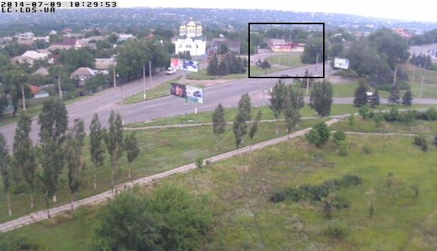
But is this a fabrication as the Russian government claims? It appears not, the following images were posted on the Euromaidan Twitter account, claiming to show the real location


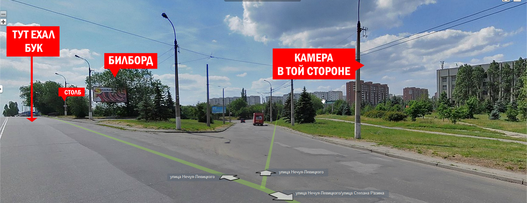
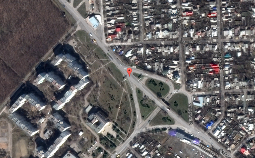
This position was inside the rebel controlled city of Luhansk, around 50km away from the areas the launcher was reportedly sighted in earlier in the day, and around 30km away from the Russian border. But can we be sure this is correct?
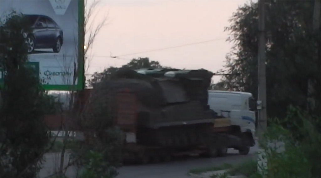
A number of people have searched for matches between images in that area, and in the video. For example, KoreanDefense.com highlighted a website with a collection of cameras in the area being shared on the internet. All the cameras have now been shut down “by order of the government”, but the preview images are still visible from before they were cut off, and the camera in the above location shows this

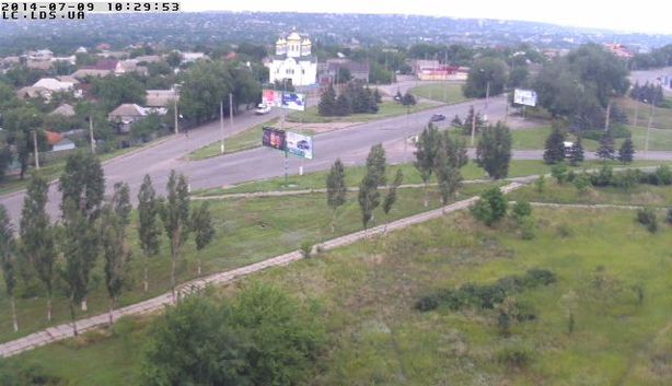
Note the billboard in the middle of the picture, which appears to match the one in the video. This also suggests the camera was point straight on to the billboard, and it appears the photograph of the area provided on the Euromaidan Twitter account is just in front of the billboard with the car advert on it visible in the above picture

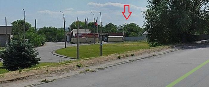
It appears the Buk video was filmed on the right hand side of the road, and we can tell the transporter is heading straight on, not taking a right. It appears the pole and path on the corner between the two road matches in both the photo and video

Others believe they’ve found some of the buildings visible in the background of the video. This image was shared by Viktor Chernov

Who then shared the following image comparing another view of the structures to what’s visible in the video

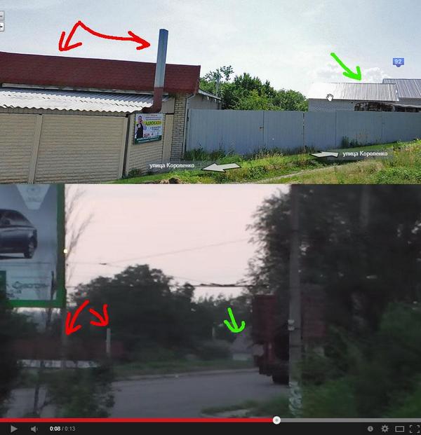
The buildings are visible in this position in the photograph from the camera

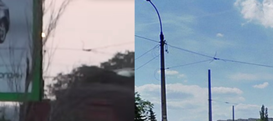
Another detail that matches are the cables suspended above the road, as these images from the video and EuromaidanPR account show

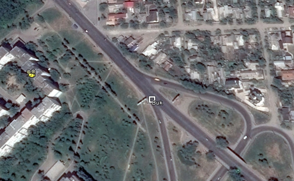
Based on the position and height of the camera, as well as the brief flash of curtain or window frame at the start of the video, is seems the video was almost certainly filmed from these apartment buildings west of the junction

It seems that based on studying the information available about this site the Russians lied when they claimed the billboard was located in government controlled territory. It’s unclear if this is yet another example of the Russian government parroting internet rumours and theories as part of their official statements, but either way, it’s increasingly clear the claims are false.
Nice summary. But just one little note: The webcams were shutdown by order of the ‘government’ of the selfproclaimed ‘Luhansk Peoples Republic’.
Looks solid.
sir, thanks a lot for you analysis. This basically shows that in all likelyhood Buk was in Luhansk. However, Ukranian original claim was that the video was shot in Krasnodon, right on Russian border, aftet the shooting of MH 17 see https://m.facebook.com/arsen.avakov.1/posts/670837696339673
It is well known to all who follows conflict that Rebels got Buk equipment from Ukr army and paraded it a lot in Luhansk some time ago, and this equipment was said by Ukr army and later by rebels as useless.
Anyway, is my understanding correct in saying that your analysis that video was likely shot in Luhansk, not Krasnodon? If so, in all likelyhood it has nothing to do with aftermath of the shooting; and in all likelyhood Avakov just lied.
Apparently, the original statement said that the video of the Buk was taken on its way *towards* Russia and passed through Krasnodon. Somewhere along the line, it looks like it was mistranslated that the video being taken in Krasnodon when in fact they meant the video had been taken with the Buk headed that way. At any rate, it’s Avakov that provided us with the geo-graphic coordinates that placed the video in Luhansk.
Also, the rebels did not capture the Buk from the Ukrainian military. I did an analysis of the image the DNR released of its “captured” Buk. The story isn’t legitimate because they were actually so lazy in cooking up the story, they didn’t even bother to take a new photograph of the Buk. The photography of their “captured” Buk was taken several years ago and posted online.
Rather go into detail here, please feel free to read more about the analysis here: http://www.koreandefense.com/what-might-a-deleted-buk-tweet-suggest/
“Also, the rebels did not capture the Buk from the Ukrainian military.”
There is actually no evidence the rebels ever had a BUK. US satellite imagery would have picked it up right away, and of course, they refuse to show what they have.
Your blog entry is also very weak. You’re willingness to accept the denials of the Ukrainian authorities, when it’s now common knowledge that the rebels captured enormous amounts of trophies from the Ukranian military.
Your faith in the American intelligence community is greater than my own and if you truly believe that Washington would have bothered to have satellites constantly snapping photos of Snizhne or the Donetsk regions to look for Buks when there are greater threats to American national security than the Russian military and pro-Russian separatists operating in Ukraine.
A limited supply of satellites and oh so many pressing national security threats probably makes the need for taking photos of Donetsk and Luhansk a lesser priority for the U.S. Government when they can just dole out cash to commercial satellite companies to provide similar data.
I think your distances are wrong. Worth pointing out, this place isn’t in Krasnodon as we were led to believe. Clear the Ukrainian authorities are trying to blame Russia for the mess in the East. All the governments involved should release their data. In this instance, it would be helpful to have verifiable evidence of when this footage was taken and to have the whole of it released.
Stupid russians dont check information before lie: that cables from trolleybus, there is no trolleybus in city Krasnoarmeysk (controlled by Ukraine), that place is Luhansk (controlled by russian terrorists) where trolleybus runs.
Can you geolocate this? https://www.youtube.com/watch?v=6OJs1dksRwk
Yep, it’s 48° 1’1.38″N, 38°18’6.04″E, supposedly filmed at 11:40am on July 17th.
Is it possible to check the video for consistency with weather for previous 3-4 days? And, at least to my naked eye, I can not see how many missiles.
If 3, then 3 missiles in, 3 out – no launch. If 4 (and it can be assumed as 4), then one missile was fired => strongest evidence so far rebels fired it.
Now, going back couple of days, AN-26 was shut down exactly in the area, allegedly at 6.5 km attitude (manpad not enough). I did not see any good pictures of the wreck, but some junk that I seen might be argued as shrapnel. So, if video is on June 17 => rebels fired a missile on this day; if the video is earlier => nothing so far.
Looks weak, nothing lines up neatly. Why not send someone that takes a picture with the right angle. And what about the address of the car dealership? Why so far away?
The picture published showing the whole of the car dealer’s billboard, shows that it has/had a large arrow and “1KM” of the left-hand side, pointing to the right. It’s not “so far away”.
The address given on the ad is at the far end of the blocks of buildings from where the video was taken – i.e. off the bottom left-hand corner of the aerial view of the roads (near top of this page).
This has been pointed out before, but isn’t included in the text above.
You can also find the location of the dealer by Googling their phone number, which was on the ad.
Where can I see these details on the sign in the video of the Buk on the truck rather than on the sign you claim to be the same sign in Lugansk?
These green bordered car signs are all over Ukraine, it’s Ukraine’s locally based car manufacturer, Bogdan.
As part of their deception attempts the Ru MOD has tried to use the laymans lack of understanding of air traffic control in creating a scenario involving a phantom SU25
here is my explanation of air traffic management systems and how the recording the RU MOD use shows nothing but the destruction of MH17. no SU25 to be seen.
http://wp.me/p4Ab1s-2e
“here is my explanation of air traffic management systems and how the recording the RU MOD use shows nothing but the destruction of MH17. no SU25 to be seen.”
Then why doesn’t the Kiev government release the records of the air traffic communications between Kiev and MH17?
The video https://www.youtube.com/watch?v=Q3MomxNHnUA&list=UUWRZ7gEgbry5FI2-46EX3jA is from official Ukranian Mililitary channel at 4minutes 47 seconds and later show Buk 11 M1 operating by Ukranian military, supposedly at 16.07.2014 in the area. It will be interesting to geolocate it, and match to striking distance and alleged by Russian positions.
They lied about the radar data too, here is an experts insight:
Russian ATC lesson 101 – the phantom SU25
http://whoisstrelkov.wordpress.com/2014/07/23/russian-atc-lesson-101-the-phantom-su25/
On topic: Why would anyone rent a billboard in the same town, isn’t it wiser to advertise in surrounding towns? It makes no logical sense from Russia to say that this advertisement exists only in the same town as the dealer.
Maybe you have not seen this before, I found another clear evidence for the real location of the video: In Google Panoramio you can find this photo, made and uploaded in October 2013: http://www.panoramio.com/photo/97652158
It’s simply misplaced a little bit, at the wrong corner of the building where it is made from. But it is of good quality and you can recognize exactly the same structures as in the video, e.g. the small houses in the background and others.